You are here: Home > Network List > Z910 - Southeastern Suture of the Appalachian Margin Experiment Stations List
> Station D18 Kastner Property, Clarkesville, GA > Earthquake Result Viewer
D18 Kastner Property, Clarkesville, GA - Earthquake Result Viewer
| Earthquake location: |
Near Coast Of Northern Chile |
| Earthquake latitude/longitude: |
-19.9/-70.6 |
| Earthquake time(UTC): |
2014/03/16 (075) 21:16:30 GMT |
| Earthquake Depth: |
20 km |
| Earthquake Magnitude: |
6.7 MWW, 6.7 MWC, 7.0 MI |
| Earthquake Catalog/Contributor: |
NEIC PDE/NEIC COMCAT |
|
| Network: |
Z9 Southeastern Suture of the Appalachian Margin Experiment |
| Station: |
D18 Kastner Property, Clarkesville, GA |
| Lat/Lon: |
34.73 N/83.61 W |
| Elevation: |
487 m |
|
| Distance: |
55.7 deg |
| Az: |
347.062 deg |
| Baz: |
165.18 deg |
| Ray Param: |
0.06457221 |
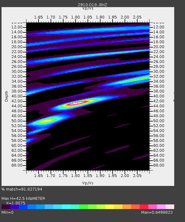
| Estimated Moho Depth: |
42.5 km |
| Estimated Crust Vp/Vs: |
1.81 |
| Assumed Crust Vp: |
6.35 km/s |
| Estimated Crust Vs: |
3.513 km/s |
| Estimated Crust Poisson's Ratio: |
0.28 |
|
| Radial Match: |
91.827194 % |
| Radial Bump: |
393 |
| Transverse Match: |
44.630993 % |
| Transverse Bump: |
400 |
| SOD ConfigId: |
3390531 |
| Insert Time: |
2019-04-10 17:00:51.506 +0000 |
| GWidth: |
2.5 |
| Max Bumps: |
400 |
| Tol: |
0.001 |
|

Signal To Noise
| Channel | StoN | STA | LTA |
| Z9:D18: :BHZ:20140316T21:25:34.660015Z | 14.058118 | 4.1896446E-6 | 2.9802314E-7 |
| Z9:D18: :BHN:20140316T21:25:34.660015Z | 10.1507225 | 2.1744172E-6 | 2.1421306E-7 |
| Z9:D18: :BHE:20140316T21:25:34.660015Z | 2.5877151 | 6.9722444E-7 | 2.6943633E-7 |
| Arrivals |
| Ps | 5.7 SECOND |
| PpPs | 18 SECOND |
| PsPs/PpSs | 24 SECOND |


