You are here: Home > Network List > TA - USArray Transportable Network (new EarthScope stations) Stations List
> Station R33A Olander Ranch, Little River, KS, USA > Earthquake Result Viewer
R33A Olander Ranch, Little River, KS, USA - Earthquake Result Viewer
| Earthquake location: |
Costa Rica |
| Earthquake latitude/longitude: |
10.0/-84.3 |
| Earthquake time(UTC): |
2011/05/13 (133) 22:47:54 GMT |
| Earthquake Depth: |
73 km |
| Earthquake Magnitude: |
5.6 MB, 5.9 MW, 6.0 MW |
| Earthquake Catalog/Contributor: |
WHDF/NEIC |
|
| Network: |
TA USArray Transportable Network (new EarthScope stations) |
| Station: |
R33A Olander Ranch, Little River, KS, USA |
| Lat/Lon: |
38.31 N/97.98 W |
| Elevation: |
497 m |
|
| Distance: |
30.8 deg |
| Az: |
338.699 deg |
| Baz: |
152.941 deg |
| Ray Param: |
0.07913132 |
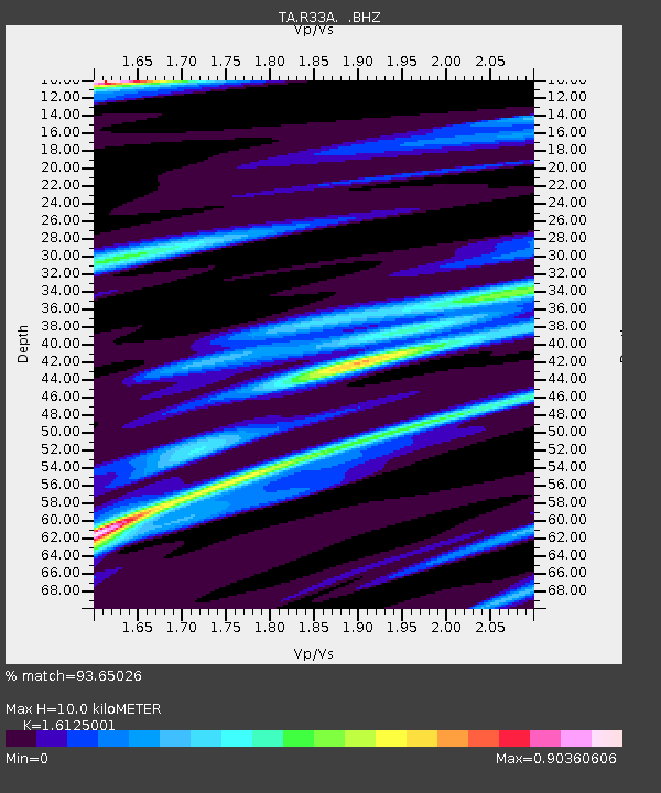
| Estimated Moho Depth: |
10.0 km |
| Estimated Crust Vp/Vs: |
1.61 |
| Assumed Crust Vp: |
6.483 km/s |
| Estimated Crust Vs: |
4.02 km/s |
| Estimated Crust Poisson's Ratio: |
0.19 |
|
| Radial Match: |
93.65026 % |
| Radial Bump: |
301 |
| Transverse Match: |
58.24746 % |
| Transverse Bump: |
400 |
| SOD ConfigId: |
390285 |
| Insert Time: |
2011-10-18 08:18:25.400 +0000 |
| GWidth: |
2.5 |
| Max Bumps: |
400 |
| Tol: |
0.001 |
|

Signal To Noise
| Channel | StoN | STA | LTA |
| TA:R33A: :BHZ:20110513T22:53:32.475006Z | 8.396827 | 9.950423E-7 | 1.1850219E-7 |
| TA:R33A: :BHN:20110513T22:53:32.475006Z | 2.4670436 | 3.9345764E-7 | 1.594855E-7 |
| TA:R33A: :BHE:20110513T22:53:32.475006Z | 1.4225835 | 3.3169283E-7 | 2.3316228E-7 |
| Arrivals |
| Ps | 1.0 SECOND |
| PpPs | 3.7 SECOND |
| PsPs/PpSs | 4.7 SECOND |


