You are here: Home > Network List > TA - USArray Transportable Network (new EarthScope stations) Stations List
> Station N34A Lincoln, NE, USA > Earthquake Result Viewer
N34A Lincoln, NE, USA - Earthquake Result Viewer
| Earthquake location: |
Costa Rica |
| Earthquake latitude/longitude: |
10.0/-84.3 |
| Earthquake time(UTC): |
2011/05/13 (133) 22:47:54 GMT |
| Earthquake Depth: |
73 km |
| Earthquake Magnitude: |
5.6 MB, 5.9 MW, 6.0 MW |
| Earthquake Catalog/Contributor: |
WHDF/NEIC |
|
| Network: |
TA USArray Transportable Network (new EarthScope stations) |
| Station: |
N34A Lincoln, NE, USA |
| Lat/Lon: |
40.84 N/96.50 W |
| Elevation: |
401 m |
|
| Distance: |
32.6 deg |
| Az: |
342.703 deg |
| Baz: |
157.291 deg |
| Ray Param: |
0.07840705 |
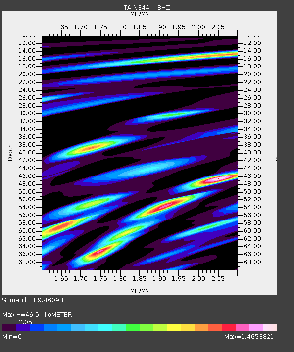
| Estimated Moho Depth: |
46.5 km |
| Estimated Crust Vp/Vs: |
2.05 |
| Assumed Crust Vp: |
6.498 km/s |
| Estimated Crust Vs: |
3.17 km/s |
| Estimated Crust Poisson's Ratio: |
0.34 |
|
| Radial Match: |
89.46098 % |
| Radial Bump: |
400 |
| Transverse Match: |
41.88971 % |
| Transverse Bump: |
400 |
| SOD ConfigId: |
390285 |
| Insert Time: |
2011-10-18 08:19:44.716 +0000 |
| GWidth: |
2.5 |
| Max Bumps: |
400 |
| Tol: |
0.001 |
|
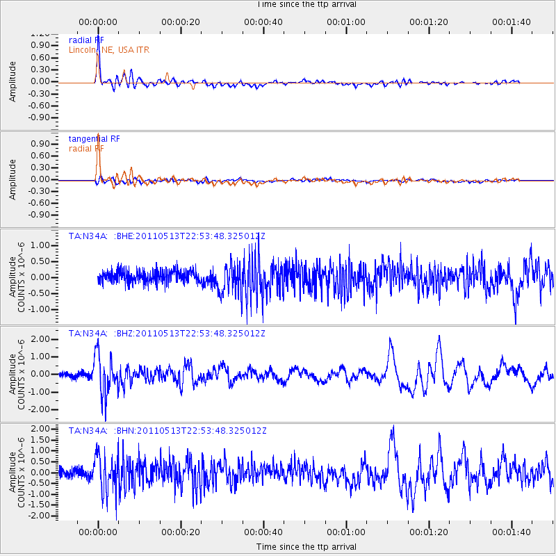
Signal To Noise
| Channel | StoN | STA | LTA |
| TA:N34A: :BHZ:20110513T22:53:48.325012Z | 9.235365 | 1.1334442E-6 | 1.227287E-7 |
| TA:N34A: :BHN:20110513T22:53:48.325012Z | 4.7298374 | 8.470286E-7 | 1.7908197E-7 |
| TA:N34A: :BHE:20110513T22:53:48.325012Z | 2.7189481 | 4.837744E-7 | 1.7792705E-7 |
| Arrivals |
| Ps | 8.1 SECOND |
| PpPs | 20 SECOND |
| PsPs/PpSs | 28 SECOND |


