You are here: Home > Network List > TA - USArray Transportable Network (new EarthScope stations) Stations List
> Station K33A Hardington, NE, USA > Earthquake Result Viewer
K33A Hardington, NE, USA - Earthquake Result Viewer
| Earthquake location: |
Costa Rica |
| Earthquake latitude/longitude: |
10.0/-84.3 |
| Earthquake time(UTC): |
2011/05/13 (133) 22:47:54 GMT |
| Earthquake Depth: |
73 km |
| Earthquake Magnitude: |
5.6 MB, 5.9 MW, 6.0 MW |
| Earthquake Catalog/Contributor: |
WHDF/NEIC |
|
| Network: |
TA USArray Transportable Network (new EarthScope stations) |
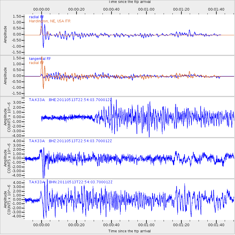
| Station: |
K33A Hardington, NE, USA |
| Lat/Lon: |
42.61 N/97.00 W |
| Elevation: |
507 m |
|
| Distance: |
34.4 deg |
| Az: |
343.307 deg |
| Baz: |
157.463 deg |
| Ray Param: |
0.07756804 |
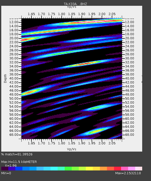
| Estimated Moho Depth: |
11.5 km |
| Estimated Crust Vp/Vs: |
1.96 |
| Assumed Crust Vp: |
6.498 km/s |
| Estimated Crust Vs: |
3.315 km/s |
| Estimated Crust Poisson's Ratio: |
0.32 |
|
| Radial Match: |
81.39526 % |
| Radial Bump: |
400 |
| Transverse Match: |
65.11023 % |
| Transverse Bump: |
400 |
| SOD ConfigId: |
390285 |
| Insert Time: |
2011-10-18 08:21:34.759 +0000 |
| GWidth: |
2.5 |
| Max Bumps: |
400 |
| Tol: |
0.001 |
|
Signal To Noise
| Channel | StoN | STA | LTA |
| TA:K33A: :BHZ:20110513T22:54:03.700012Z | 6.957627 | 1.6109998E-6 | 2.3154443E-7 |
| TA:K33A: :BHN:20110513T22:54:03.700012Z | 8.346374 | 2.1997573E-6 | 2.635585E-7 |
| TA:K33A: :BHE:20110513T22:54:03.700012Z | 2.396625 | 6.458858E-7 | 2.6949806E-7 |
| Arrivals |
| Ps | 1.8 SECOND |
| PpPs | 4.9 SECOND |
| PsPs/PpSs | 6.7 SECOND |


