You are here: Home > Network List > TA - USArray Transportable Network (new EarthScope stations) Stations List
> Station H34A Spellman Lake, Hanley Falls, MN, USA > Earthquake Result Viewer
H34A Spellman Lake, Hanley Falls, MN, USA - Earthquake Result Viewer
| Earthquake location: |
Costa Rica |
| Earthquake latitude/longitude: |
10.0/-84.3 |
| Earthquake time(UTC): |
2011/05/13 (133) 22:47:54 GMT |
| Earthquake Depth: |
73 km |
| Earthquake Magnitude: |
5.6 MB, 5.9 MW, 6.0 MW |
| Earthquake Catalog/Contributor: |
WHDF/NEIC |
|
| Network: |
TA USArray Transportable Network (new EarthScope stations) |
| Station: |
H34A Spellman Lake, Hanley Falls, MN, USA |
| Lat/Lon: |
44.67 N/95.78 W |
| Elevation: |
329 m |
|
| Distance: |
36.0 deg |
| Az: |
346.03 deg |
| Baz: |
160.531 deg |
| Ray Param: |
0.07671592 |
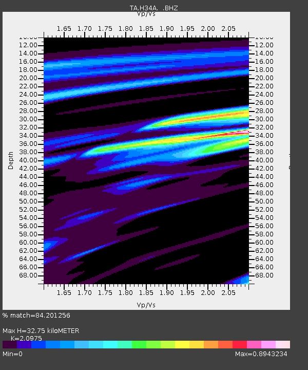
| Estimated Moho Depth: |
32.75 km |
| Estimated Crust Vp/Vs: |
2.10 |
| Assumed Crust Vp: |
6.571 km/s |
| Estimated Crust Vs: |
3.133 km/s |
| Estimated Crust Poisson's Ratio: |
0.35 |
|
| Radial Match: |
84.201256 % |
| Radial Bump: |
336 |
| Transverse Match: |
33.68968 % |
| Transverse Bump: |
400 |
| SOD ConfigId: |
390285 |
| Insert Time: |
2011-10-18 08:21:42.057 +0000 |
| GWidth: |
2.5 |
| Max Bumps: |
400 |
| Tol: |
0.001 |
|
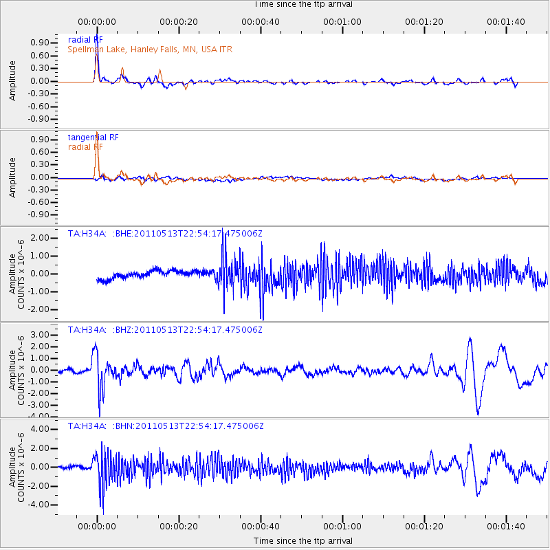
Signal To Noise
| Channel | StoN | STA | LTA |
| TA:H34A: :BHZ:20110513T22:54:17.475006Z | 11.567215 | 1.500023E-6 | 1.2967884E-7 |
| TA:H34A: :BHN:20110513T22:54:17.475006Z | 9.720044 | 1.7230518E-6 | 1.7726789E-7 |
| TA:H34A: :BHE:20110513T22:54:17.475006Z | 4.1082726 | 8.6736213E-7 | 2.1112574E-7 |
| Arrivals |
| Ps | 5.8 SECOND |
| PpPs | 14 SECOND |
| PsPs/PpSs | 20 SECOND |


