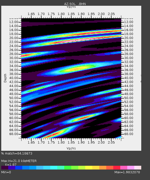
SOL AZ.SOL - Earthquake Result Viewer

Earthquake location: Rat Islands, Aleutian Islands
Earthquake latitude/longitude: 50.4/177.0
Earthquake time(UTC): 2009/07/06 (187) 14:53:12 GMT
Earthquake Depth: 22 km
Earthquake Magnitude: 6.0 MB, 5.8 MS, 6.1 MW, 6.0 MW
Earthquake Catalog/Contributor: WHDF/NEIC
Network: AZ ANZA Regional Network
Station: SOL AZ.SOL
Lat/Lon: 32.84 N/117.25 W
Elevation: 245 m
Distance: 50.5 deg
Az: 84.091 deg
Baz: 310.921 deg
Ray Param: 0.06797817
Estimated Moho Depth: 21.0 km
Estimated Crust Vp/Vs: 1.87
Assumed Crust Vp: 6.264 km/s
Estimated Crust Vs: 3.35 km/s
Estimated Crust Poisson's Ratio: 0.30
Radial Match: 84.18673 %
Radial Bump: 400
Transverse Match: 86.390366 %
Transverse Bump: 400
SOD ConfigId: 2648
Insert Time: 2010-02-26 21:05:28.815 +0000
GWidth: 2.5
Max Bumps: 400
Tol: 0.001

Signal To Noise

ChannelStoNSTALTA
AZ:SOL: :BHN:20090706T15:01:37.768992Z7.19608643.910024E-65.4335425E-7
AZ:SOL: :BHE:20090706T15:01:37.768992Z3.48201272.5649058E-67.3661585E-7
AZ:SOL: :BHZ:20090706T15:01:37.768992Z2.8477772.3117557E-68.117756E-7
Arrivals
Ps3.1 SECOND
PpPs9.1 SECOND
PsPs/PpSs12 SECOND