You are here: Home > Network List > TA - USArray Transportable Network (new EarthScope stations) Stations List
> Station J33A Davis, SD, USA > Earthquake Result Viewer
J33A Davis, SD, USA - Earthquake Result Viewer
| Earthquake location: |
Costa Rica |
| Earthquake latitude/longitude: |
10.0/-84.3 |
| Earthquake time(UTC): |
2011/05/13 (133) 22:47:54 GMT |
| Earthquake Depth: |
73 km |
| Earthquake Magnitude: |
5.6 MB, 5.9 MW, 6.0 MW |
| Earthquake Catalog/Contributor: |
WHDF/NEIC |
|
| Network: |
TA USArray Transportable Network (new EarthScope stations) |
| Station: |
J33A Davis, SD, USA |
| Lat/Lon: |
43.32 N/96.97 W |
| Elevation: |
400 m |
|
| Distance: |
35.0 deg |
| Az: |
343.824 deg |
| Baz: |
157.911 deg |
| Ray Param: |
0.07723268 |
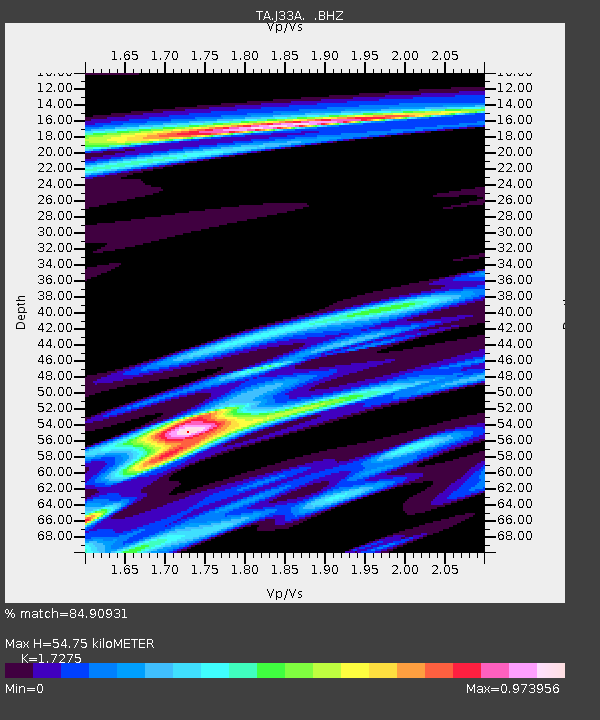
| Estimated Moho Depth: |
54.75 km |
| Estimated Crust Vp/Vs: |
1.73 |
| Assumed Crust Vp: |
6.498 km/s |
| Estimated Crust Vs: |
3.761 km/s |
| Estimated Crust Poisson's Ratio: |
0.25 |
|
| Radial Match: |
84.90931 % |
| Radial Bump: |
400 |
| Transverse Match: |
51.088245 % |
| Transverse Bump: |
400 |
| SOD ConfigId: |
390285 |
| Insert Time: |
2011-10-18 08:22:04.210 +0000 |
| GWidth: |
2.5 |
| Max Bumps: |
400 |
| Tol: |
0.001 |
|
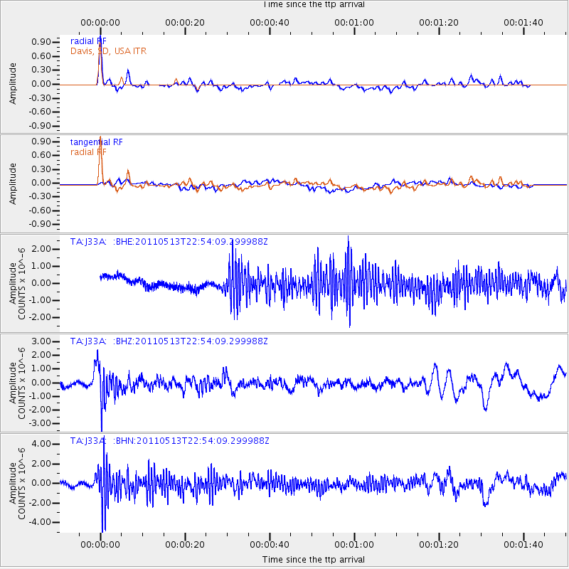
Signal To Noise
| Channel | StoN | STA | LTA |
| TA:J33A: :BHZ:20110513T22:54:09.299988Z | 7.358876 | 1.2097483E-6 | 1.6439309E-7 |
| TA:J33A: :BHN:20110513T22:54:09.299988Z | 10.35742 | 1.8747136E-6 | 1.81002E-7 |
| TA:J33A: :BHE:20110513T22:54:09.299988Z | 3.4038022 | 1.0137566E-6 | 2.9783064E-7 |
| Arrivals |
| Ps | 6.6 SECOND |
| PpPs | 21 SECOND |
| PsPs/PpSs | 28 SECOND |


