You are here: Home > Network List > TA - USArray Transportable Network (new EarthScope stations) Stations List
> Station F33A 5 Mile Ranch, Herman, MN, USA > Earthquake Result Viewer
F33A 5 Mile Ranch, Herman, MN, USA - Earthquake Result Viewer
| Earthquake location: |
Costa Rica |
| Earthquake latitude/longitude: |
10.0/-84.3 |
| Earthquake time(UTC): |
2011/05/13 (133) 22:47:54 GMT |
| Earthquake Depth: |
73 km |
| Earthquake Magnitude: |
5.6 MB, 5.9 MW, 6.0 MW |
| Earthquake Catalog/Contributor: |
WHDF/NEIC |
|
| Network: |
TA USArray Transportable Network (new EarthScope stations) |
| Station: |
F33A 5 Mile Ranch, Herman, MN, USA |
| Lat/Lon: |
45.84 N/96.29 W |
| Elevation: |
313 m |
|
| Distance: |
37.2 deg |
| Az: |
346.115 deg |
| Baz: |
160.234 deg |
| Ray Param: |
0.07605045 |
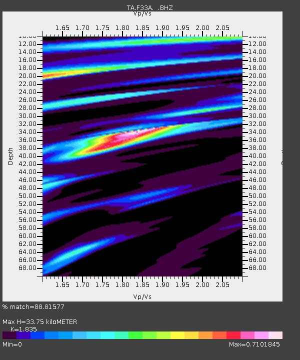
| Estimated Moho Depth: |
33.75 km |
| Estimated Crust Vp/Vs: |
1.84 |
| Assumed Crust Vp: |
6.552 km/s |
| Estimated Crust Vs: |
3.571 km/s |
| Estimated Crust Poisson's Ratio: |
0.29 |
|
| Radial Match: |
88.81577 % |
| Radial Bump: |
332 |
| Transverse Match: |
48.821644 % |
| Transverse Bump: |
400 |
| SOD ConfigId: |
390285 |
| Insert Time: |
2011-10-18 08:24:06.189 +0000 |
| GWidth: |
2.5 |
| Max Bumps: |
400 |
| Tol: |
0.001 |
|
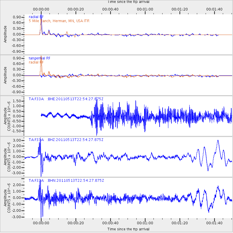
Signal To Noise
| Channel | StoN | STA | LTA |
| TA:F33A: :BHZ:20110513T22:54:27.875Z | 12.651086 | 1.377032E-6 | 1.0884695E-7 |
| TA:F33A: :BHN:20110513T22:54:27.875Z | 7.7389083 | 1.1760675E-6 | 1.5196814E-7 |
| TA:F33A: :BHE:20110513T22:54:27.875Z | 5.863116 | 7.834562E-7 | 1.3362454E-7 |
| Arrivals |
| Ps | 4.6 SECOND |
| PpPs | 14 SECOND |
| PsPs/PpSs | 18 SECOND |


