You are here: Home > Network List > ZL11 - Northern Embayment Lithospheric Experiment Stations List
> Station A01 Waterford, MS, USA > Earthquake Result Viewer
A01 Waterford, MS, USA - Earthquake Result Viewer
| Earthquake location: |
Near Coast Of Northern Chile |
| Earthquake latitude/longitude: |
-19.9/-70.6 |
| Earthquake time(UTC): |
2014/03/16 (075) 21:16:30 GMT |
| Earthquake Depth: |
20 km |
| Earthquake Magnitude: |
6.7 MWW, 6.7 MWC, 7.0 MI |
| Earthquake Catalog/Contributor: |
NEIC PDE/NEIC COMCAT |
|
| Network: |
ZL Northern Embayment Lithospheric Experiment |
| Station: |
A01 Waterford, MS, USA |
| Lat/Lon: |
34.62 N/89.51 W |
| Elevation: |
145 m |
|
| Distance: |
57.1 deg |
| Az: |
341.479 deg |
| Baz: |
158.752 deg |
| Ray Param: |
0.06365754 |
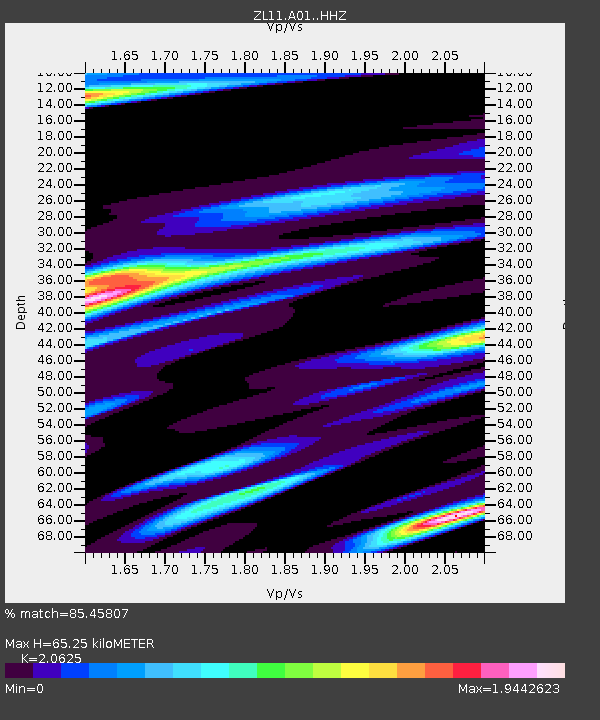
| Estimated Moho Depth: |
65.25 km |
| Estimated Crust Vp/Vs: |
2.06 |
| Assumed Crust Vp: |
6.38 km/s |
| Estimated Crust Vs: |
3.094 km/s |
| Estimated Crust Poisson's Ratio: |
0.35 |
|
| Radial Match: |
85.45807 % |
| Radial Bump: |
361 |
| Transverse Match: |
67.164536 % |
| Transverse Bump: |
400 |
| SOD ConfigId: |
3390531 |
| Insert Time: |
2019-04-10 17:01:41.185 +0000 |
| GWidth: |
2.5 |
| Max Bumps: |
400 |
| Tol: |
0.001 |
|

Signal To Noise
| Channel | StoN | STA | LTA |
| ZL:A01: :HHZ:20140316T21:25:44.629985Z | 44.793903 | 7.430727E-6 | 1.6588702E-7 |
| ZL:A01: :HHN:20140316T21:25:44.629985Z | 9.909709 | 3.4263994E-6 | 3.4576186E-7 |
| ZL:A01: :HHE:20140316T21:25:44.629985Z | 2.489337 | 9.732889E-7 | 3.9098316E-7 |
| Arrivals |
| Ps | 11 SECOND |
| PpPs | 30 SECOND |
| PsPs/PpSs | 41 SECOND |


