You are here: Home > Network List > TA - USArray Transportable Network (new EarthScope stations) Stations List
> Station D33A AnnSam, Waubun, MN, USA > Earthquake Result Viewer
D33A AnnSam, Waubun, MN, USA - Earthquake Result Viewer
| Earthquake location: |
Costa Rica |
| Earthquake latitude/longitude: |
10.0/-84.3 |
| Earthquake time(UTC): |
2011/05/13 (133) 22:47:54 GMT |
| Earthquake Depth: |
73 km |
| Earthquake Magnitude: |
5.6 MB, 5.9 MW, 6.0 MW |
| Earthquake Catalog/Contributor: |
WHDF/NEIC |
|
| Network: |
TA USArray Transportable Network (new EarthScope stations) |
| Station: |
D33A AnnSam, Waubun, MN, USA |
| Lat/Lon: |
47.14 N/95.84 W |
| Elevation: |
466 m |
|
| Distance: |
38.3 deg |
| Az: |
347.289 deg |
| Baz: |
161.486 deg |
| Ray Param: |
0.07540046 |
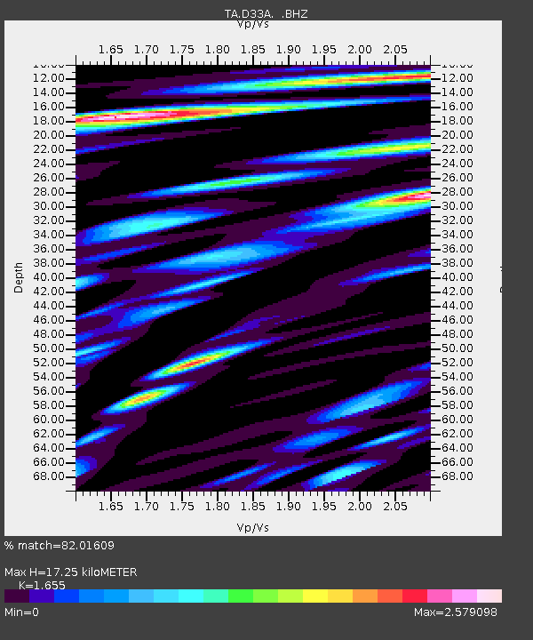
| Estimated Moho Depth: |
17.25 km |
| Estimated Crust Vp/Vs: |
1.65 |
| Assumed Crust Vp: |
6.419 km/s |
| Estimated Crust Vs: |
3.879 km/s |
| Estimated Crust Poisson's Ratio: |
0.21 |
|
| Radial Match: |
82.01609 % |
| Radial Bump: |
400 |
| Transverse Match: |
52.03872 % |
| Transverse Bump: |
400 |
| SOD ConfigId: |
390285 |
| Insert Time: |
2011-10-18 08:25:08.926 +0000 |
| GWidth: |
2.5 |
| Max Bumps: |
400 |
| Tol: |
0.001 |
|

Signal To Noise
| Channel | StoN | STA | LTA |
| TA:D33A: :BHZ:20110513T22:54:37.375Z | 21.9812 | 2.2880213E-6 | 1.04089914E-7 |
| TA:D33A: :BHN:20110513T22:54:37.375Z | 10.716996 | 2.2004508E-6 | 2.0532347E-7 |
| TA:D33A: :BHE:20110513T22:54:37.375Z | 6.490295 | 1.1703711E-6 | 1.8032632E-7 |
| Arrivals |
| Ps | 1.9 SECOND |
| PpPs | 6.6 SECOND |
| PsPs/PpSs | 8.5 SECOND |


