You are here: Home > Network List > TA - USArray Transportable Network (new EarthScope stations) Stations List
> Station C37A Embarrass, MN, USA > Earthquake Result Viewer
C37A Embarrass, MN, USA - Earthquake Result Viewer
| Earthquake location: |
Costa Rica |
| Earthquake latitude/longitude: |
10.0/-84.3 |
| Earthquake time(UTC): |
2011/05/13 (133) 22:47:54 GMT |
| Earthquake Depth: |
73 km |
| Earthquake Magnitude: |
5.6 MB, 5.9 MW, 6.0 MW |
| Earthquake Catalog/Contributor: |
WHDF/NEIC |
|
| Network: |
TA USArray Transportable Network (new EarthScope stations) |
| Station: |
C37A Embarrass, MN, USA |
| Lat/Lon: |
47.73 N/92.19 W |
| Elevation: |
447 m |
|
| Distance: |
38.2 deg |
| Az: |
351.407 deg |
| Baz: |
167.406 deg |
| Ray Param: |
0.07545782 |
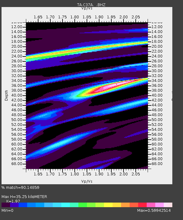
| Estimated Moho Depth: |
35.25 km |
| Estimated Crust Vp/Vs: |
1.97 |
| Assumed Crust Vp: |
6.571 km/s |
| Estimated Crust Vs: |
3.335 km/s |
| Estimated Crust Poisson's Ratio: |
0.33 |
|
| Radial Match: |
90.14859 % |
| Radial Bump: |
180 |
| Transverse Match: |
41.30255 % |
| Transverse Bump: |
400 |
| SOD ConfigId: |
390285 |
| Insert Time: |
2011-10-18 08:26:53.617 +0000 |
| GWidth: |
2.5 |
| Max Bumps: |
400 |
| Tol: |
0.001 |
|

Signal To Noise
| Channel | StoN | STA | LTA |
| TA:C37A: :BHZ:20110513T22:54:36.524994Z | 12.592229 | 1.1246211E-6 | 8.9310724E-8 |
| TA:C37A: :BHN:20110513T22:54:36.524994Z | 4.99434 | 7.973956E-7 | 1.5965986E-7 |
| TA:C37A: :BHE:20110513T22:54:36.524994Z | 1.2155302 | 2.783177E-7 | 2.2896816E-7 |
| Arrivals |
| Ps | 5.6 SECOND |
| PpPs | 15 SECOND |
| PsPs/PpSs | 20 SECOND |


