You are here: Home > Network List > TA - USArray Transportable Network (new EarthScope stations) Stations List
> Station I38A Scanlan Farm, Eyota, MN, USA > Earthquake Result Viewer
I38A Scanlan Farm, Eyota, MN, USA - Earthquake Result Viewer
| Earthquake location: |
Costa Rica |
| Earthquake latitude/longitude: |
10.0/-84.3 |
| Earthquake time(UTC): |
2011/05/13 (133) 22:47:54 GMT |
| Earthquake Depth: |
73 km |
| Earthquake Magnitude: |
5.6 MB, 5.9 MW, 6.0 MW |
| Earthquake Catalog/Contributor: |
WHDF/NEIC |
|
| Network: |
TA USArray Transportable Network (new EarthScope stations) |
| Station: |
I38A Scanlan Farm, Eyota, MN, USA |
| Lat/Lon: |
44.04 N/92.33 W |
| Elevation: |
390 m |
|
| Distance: |
34.7 deg |
| Az: |
349.814 deg |
| Baz: |
166.02 deg |
| Ray Param: |
0.07741658 |
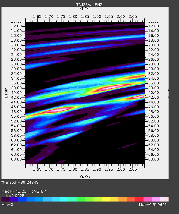
| Estimated Moho Depth: |
41.25 km |
| Estimated Crust Vp/Vs: |
2.09 |
| Assumed Crust Vp: |
6.571 km/s |
| Estimated Crust Vs: |
3.14 km/s |
| Estimated Crust Poisson's Ratio: |
0.35 |
|
| Radial Match: |
89.24843 % |
| Radial Bump: |
400 |
| Transverse Match: |
71.21464 % |
| Transverse Bump: |
400 |
| SOD ConfigId: |
390285 |
| Insert Time: |
2011-10-18 08:28:41.597 +0000 |
| GWidth: |
2.5 |
| Max Bumps: |
400 |
| Tol: |
0.001 |
|
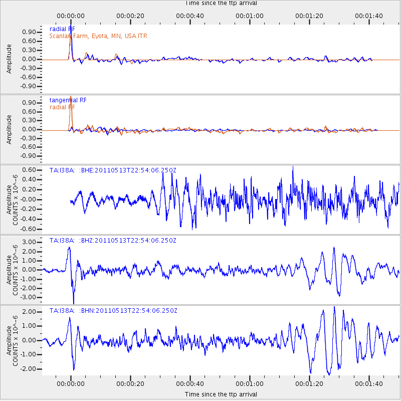
Signal To Noise
| Channel | StoN | STA | LTA |
| TA:I38A: :BHZ:20110513T22:54:06.250Z | 16.377691 | 1.4905945E-6 | 9.101372E-8 |
| TA:I38A: :BHN:20110513T22:54:06.250Z | 7.0539813 | 9.57128E-7 | 1.3568622E-7 |
| TA:I38A: :BHE:20110513T22:54:06.250Z | 3.1107497 | 2.598837E-7 | 8.354375E-8 |
| Arrivals |
| Ps | 7.3 SECOND |
| PpPs | 18 SECOND |
| PsPs/PpSs | 25 SECOND |


