You are here: Home > Network List > TA - USArray Transportable Network (new EarthScope stations) Stations List
> Station I37A Lemond, Waseca, MN, USA > Earthquake Result Viewer
I37A Lemond, Waseca, MN, USA - Earthquake Result Viewer
| Earthquake location: |
Costa Rica |
| Earthquake latitude/longitude: |
10.0/-84.3 |
| Earthquake time(UTC): |
2011/05/13 (133) 22:47:54 GMT |
| Earthquake Depth: |
73 km |
| Earthquake Magnitude: |
5.6 MB, 5.9 MW, 6.0 MW |
| Earthquake Catalog/Contributor: |
WHDF/NEIC |
|
| Network: |
TA USArray Transportable Network (new EarthScope stations) |
| Station: |
I37A Lemond, Waseca, MN, USA |
| Lat/Lon: |
44.01 N/93.40 W |
| Elevation: |
371 m |
|
| Distance: |
34.8 deg |
| Az: |
348.494 deg |
| Baz: |
164.195 deg |
| Ray Param: |
0.07732725 |
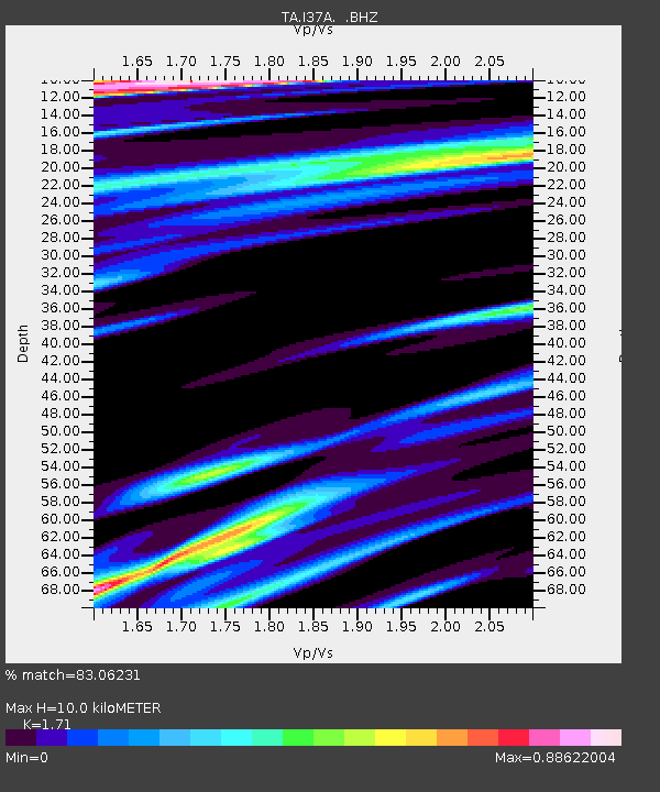
| Estimated Moho Depth: |
10.0 km |
| Estimated Crust Vp/Vs: |
1.71 |
| Assumed Crust Vp: |
6.571 km/s |
| Estimated Crust Vs: |
3.842 km/s |
| Estimated Crust Poisson's Ratio: |
0.24 |
|
| Radial Match: |
83.06231 % |
| Radial Bump: |
400 |
| Transverse Match: |
55.450077 % |
| Transverse Bump: |
400 |
| SOD ConfigId: |
390285 |
| Insert Time: |
2011-10-18 08:37:25.637 +0000 |
| GWidth: |
2.5 |
| Max Bumps: |
400 |
| Tol: |
0.001 |
|

Signal To Noise
| Channel | StoN | STA | LTA |
| TA:I37A: :BHZ:20110513T22:54:07.725006Z | 4.149942 | 1.4588124E-6 | 3.5152598E-7 |
| TA:I37A: :BHN:20110513T22:54:07.725006Z | 1.6946074 | 9.555033E-7 | 5.6384937E-7 |
| TA:I37A: :BHE:20110513T22:54:07.725006Z | 1.2256727 | 1.1566963E-6 | 9.4372353E-7 |
| Arrivals |
| Ps | 1.2 SECOND |
| PpPs | 3.8 SECOND |
| PsPs/PpSs | 5.0 SECOND |


