You are here: Home > Network List > AZ - ANZA Regional Network Stations List
> Station SOL AZ.SOL > Earthquake Result Viewer
SOL AZ.SOL - Earthquake Result Viewer

| Earthquake location: |
Fiji Islands Region |
| Earthquake latitude/longitude: |
-17.7/-178.4 |
| Earthquake time(UTC): |
2006/02/02 (033) 12:48:43 GMT |
| Earthquake Depth: |
598 km |
| Earthquake Magnitude: |
5.9 MB, 6.7 MW, 6.7 MW |
| Earthquake Catalog/Contributor: |
WHDF/NEIC |
|
| Network: |
AZ ANZA Regional Network |
| Station: |
SOL AZ.SOL |
| Lat/Lon: |
32.84 N/117.25 W |
| Elevation: |
245 m |
|
| Distance: |
77.1 deg |
| Az: |
49.153 deg |
| Baz: |
238.91 deg |
| Ray Param: |
0.048658874 |
| Estimated Moho Depth: |
31.0 km |
| Estimated Crust Vp/Vs: |
2.09 |
| Assumed Crust Vp: |
6.264 km/s |
| Estimated Crust Vs: |
3.001 km/s |
| Estimated Crust Poisson's Ratio: |
0.35 |
|
| Radial Match: |
84.64518 % |
| Radial Bump: |
400 |
| Transverse Match: |
82.91768 % |
| Transverse Bump: |
400 |
| SOD ConfigId: |
4977 |
| Insert Time: |
2010-02-26 21:05:53.731 +0000 |
| GWidth: |
2.5 |
| Max Bumps: |
400 |
| Tol: |
0.001 |
|
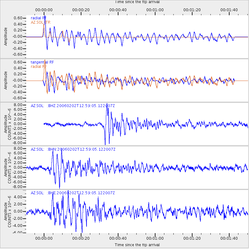
Signal To Noise
| Channel | StoN | STA | LTA |
| AZ:SOL: :BHN:20060202T12:59:05.122007Z | 4.2133346 | 2.0541197E-6 | 4.8752827E-7 |
| AZ:SOL: :BHE:20060202T12:59:05.122007Z | 3.5225565 | 1.6049491E-6 | 4.5562058E-7 |
| AZ:SOL: :BHZ:20060202T12:59:05.122007Z | 9.694714 | 3.6719323E-6 | 3.7875614E-7 |
| Arrivals |
| Ps | 5.5 SECOND |
| PpPs | 15 SECOND |
| PsPs/PpSs | 20 SECOND |


