You are here: Home > Network List > TA - USArray Transportable Network (new EarthScope stations) Stations List
> Station TPFO Pinon Flats, CA, USA > Earthquake Result Viewer
TPFO Pinon Flats, CA, USA - Earthquake Result Viewer
| Earthquake location: |
Costa Rica |
| Earthquake latitude/longitude: |
10.0/-84.3 |
| Earthquake time(UTC): |
2011/05/13 (133) 22:47:54 GMT |
| Earthquake Depth: |
73 km |
| Earthquake Magnitude: |
5.6 MB, 5.9 MW, 6.0 MW |
| Earthquake Catalog/Contributor: |
WHDF/NEIC |
|
| Network: |
TA USArray Transportable Network (new EarthScope stations) |
| Station: |
TPFO Pinon Flats, CA, USA |
| Lat/Lon: |
33.61 N/116.45 W |
| Elevation: |
1275 m |
|
| Distance: |
37.7 deg |
| Az: |
313.501 deg |
| Baz: |
121.104 deg |
| Ray Param: |
0.075739525 |
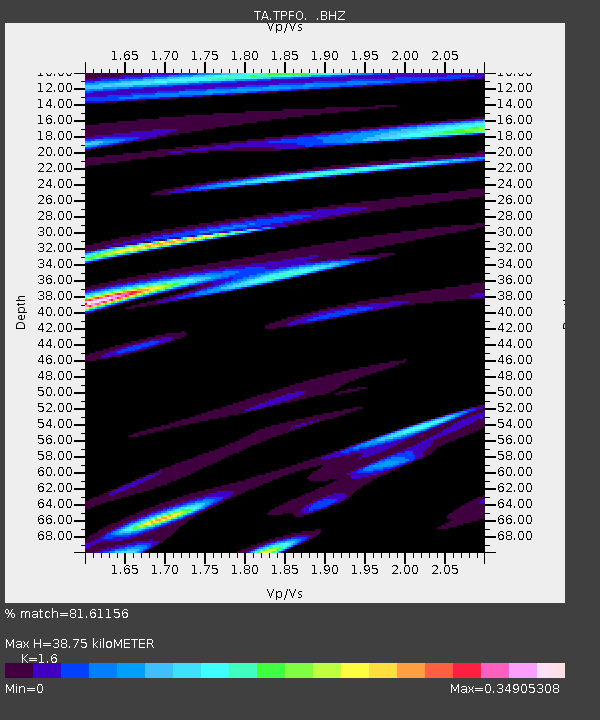
| Estimated Moho Depth: |
38.75 km |
| Estimated Crust Vp/Vs: |
1.60 |
| Assumed Crust Vp: |
6.264 km/s |
| Estimated Crust Vs: |
3.915 km/s |
| Estimated Crust Poisson's Ratio: |
0.18 |
|
| Radial Match: |
81.61156 % |
| Radial Bump: |
400 |
| Transverse Match: |
67.177704 % |
| Transverse Bump: |
378 |
| SOD ConfigId: |
390285 |
| Insert Time: |
2011-10-18 08:58:57.113 +0000 |
| GWidth: |
2.5 |
| Max Bumps: |
400 |
| Tol: |
0.001 |
|
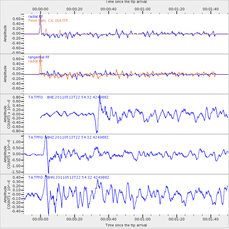
Signal To Noise
| Channel | StoN | STA | LTA |
| TA:TPFO: :BHZ:20110513T22:54:32.424988Z | 10.427895 | 7.594229E-7 | 7.2826104E-8 |
| TA:TPFO: :BHN:20110513T22:54:32.424988Z | 4.279615 | 2.428319E-7 | 5.6741534E-8 |
| TA:TPFO: :BHE:20110513T22:54:32.424988Z | 6.5128875 | 4.36553E-7 | 6.7029106E-8 |
| Arrivals |
| Ps | 4.0 SECOND |
| PpPs | 15 SECOND |
| PsPs/PpSs | 19 SECOND |


