You are here: Home > Network List > UW - Pacific Northwest Regional Seismic Network Stations List
> Station MRBL Marblemount, WA, USA > Earthquake Result Viewer
MRBL Marblemount, WA, USA - Earthquake Result Viewer
*The percent match for this event was below the threshold and hence no stack was calculated.
| Earthquake location: |
Costa Rica |
| Earthquake latitude/longitude: |
10.0/-84.3 |
| Earthquake time(UTC): |
2011/05/13 (133) 22:47:54 GMT |
| Earthquake Depth: |
73 km |
| Earthquake Magnitude: |
5.6 MB, 5.9 MW, 6.0 MW |
| Earthquake Catalog/Contributor: |
WHDF/NEIC |
|
| Network: |
UW Pacific Northwest Regional Seismic Network |
| Station: |
MRBL Marblemount, WA, USA |
| Lat/Lon: |
48.52 N/121.48 W |
| Elevation: |
75 m |
|
| Distance: |
49.4 deg |
| Az: |
328.079 deg |
| Baz: |
128.424 deg |
| Ray Param: |
$rayparam |
*The percent match for this event was below the threshold and hence was not used in the summary stack. |
|
| Radial Match: |
57.347343 % |
| Radial Bump: |
400 |
| Transverse Match: |
54.233894 % |
| Transverse Bump: |
400 |
| SOD ConfigId: |
390285 |
| Insert Time: |
2011-10-18 09:00:06.932 +0000 |
| GWidth: |
2.5 |
| Max Bumps: |
400 |
| Tol: |
0.001 |
|
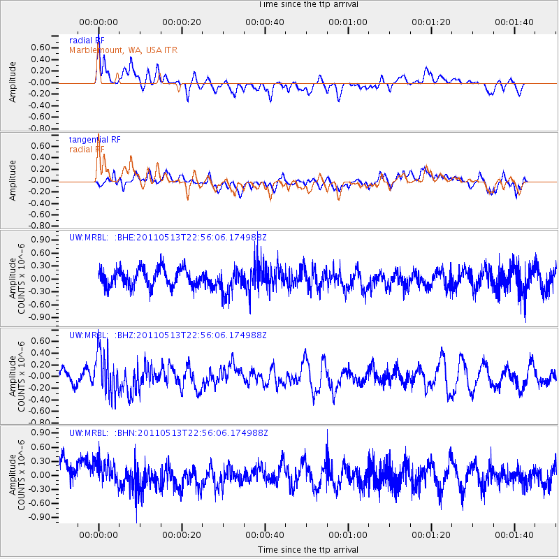
Signal To Noise
| Channel | StoN | STA | LTA |
| UW:MRBL: :BHZ:20110513T22:56:06.174988Z | 3.442545 | 3.6373842E-7 | 1.0565975E-7 |
| UW:MRBL: :BHN:20110513T22:56:06.174988Z | 1.1349168 | 2.8860757E-7 | 2.542984E-7 |
| UW:MRBL: :BHE:20110513T22:56:06.174988Z | 1.4373628 | 2.984792E-7 | 2.0765752E-7 |
| Arrivals |
| Ps | |
| PpPs | |
| PsPs/PpSs | |


