You are here: Home > Network List > CI - Caltech Regional Seismic Network Stations List
> Station LRL Laurel Mtn Radio Fac, Ridgecrest, CA, USA > Earthquake Result Viewer
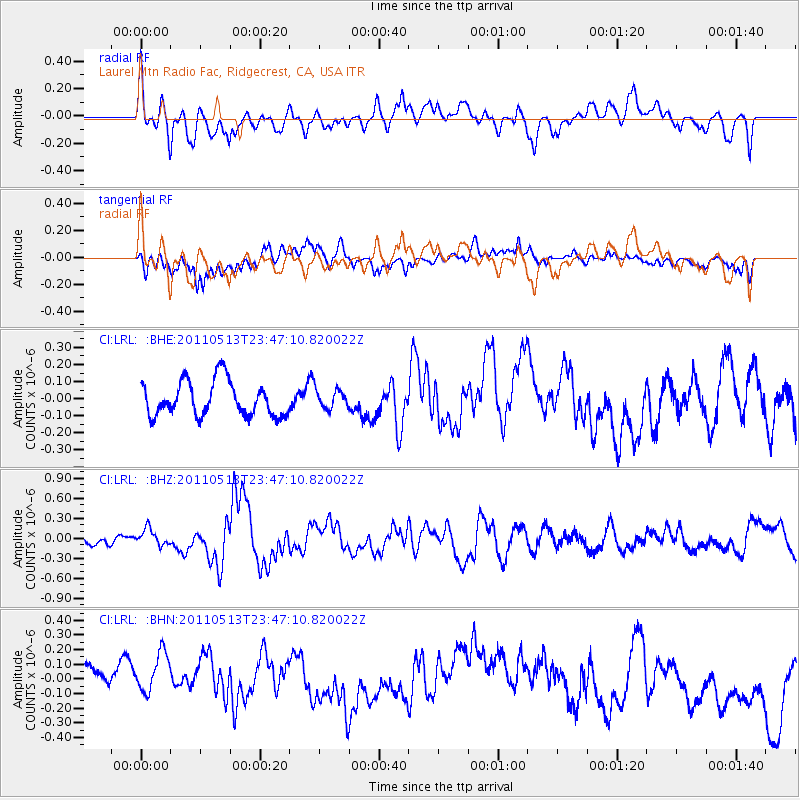
LRL Laurel Mtn Radio Fac, Ridgecrest, CA, USA - Earthquake Result Viewer
*The percent match for this event was below the threshold and hence no stack was calculated.
| Earthquake location: |
Near East Coast Of Honshu, Japan |
| Earthquake latitude/longitude: |
37.4/141.3 |
| Earthquake time(UTC): |
2011/05/13 (133) 23:35:52 GMT |
| Earthquake Depth: |
35 km |
| Earthquake Magnitude: |
5.6 MB, 5.7 MS, 6.1 MW, 5.9 MW |
| Earthquake Catalog/Contributor: |
WHDF/NEIC |
|
| Network: |
CI Caltech Regional Seismic Network |
| Station: |
LRL Laurel Mtn Radio Fac, Ridgecrest, CA, USA |
| Lat/Lon: |
35.48 N/117.68 W |
| Elevation: |
1340 m |
|
| Distance: |
77.0 deg |
| Az: |
55.33 deg |
| Baz: |
306.626 deg |
| Ray Param: |
$rayparam |
*The percent match for this event was below the threshold and hence was not used in the summary stack. |
|
| Radial Match: |
50.702335 % |
| Radial Bump: |
400 |
| Transverse Match: |
44.687607 % |
| Transverse Bump: |
400 |
| SOD ConfigId: |
390285 |
| Insert Time: |
2011-10-18 09:08:52.296 +0000 |
| GWidth: |
2.5 |
| Max Bumps: |
400 |
| Tol: |
0.001 |
|
Signal To Noise
| Channel | StoN | STA | LTA |
| CI:LRL: :BHZ:20110513T23:47:10.820022Z | 1.5561162 | 1.273427E-7 | 8.183366E-8 |
| CI:LRL: :BHN:20110513T23:47:10.820022Z | 1.3613526 | 1.9334071E-7 | 1.4202104E-7 |
| CI:LRL: :BHE:20110513T23:47:10.820022Z | 0.54977393 | 5.5737065E-8 | 1.0138178E-7 |
| Arrivals |
| Ps | |
| PpPs | |
| PsPs/PpSs | |


