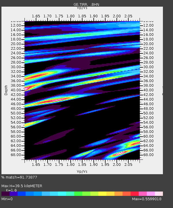
TIRR GEOFON Station Tirgusor, Romania - Earthquake Result Viewer

Earthquake location: Near East Coast Of Honshu, Japan
Earthquake latitude/longitude: 37.4/141.3
Earthquake time(UTC): 2011/05/13 (133) 23:35:52 GMT
Earthquake Depth: 35 km
Earthquake Magnitude: 5.6 MB, 5.7 MS, 6.1 MW, 5.9 MW
Earthquake Catalog/Contributor: WHDF/NEIC
Network: GE GEOFON
Station: TIRR GEOFON Station Tirgusor, Romania
Lat/Lon: 44.46 N/28.41 E
Elevation: 77 m
Distance: 78.5 deg
Az: 317.692 deg
Baz: 48.47 deg
Ray Param: 0.04957117
Estimated Moho Depth: 39.5 km
Estimated Crust Vp/Vs: 1.60
Assumed Crust Vp: 6.12 km/s
Estimated Crust Vs: 3.825 km/s
Estimated Crust Poisson's Ratio: 0.18
Radial Match: 91.73877 %
Radial Bump: 400
Transverse Match: 80.522835 %
Transverse Bump: 400
SOD ConfigId: 390285
Insert Time: 2011-10-18 09:11:28.210 +0000
GWidth: 2.5
Max Bumps: 400
Tol: 0.001

Signal To Noise

ChannelStoNSTALTA
GE:TIRR: :BHZ:20110513T23:47:19.240005Z6.971614.903856E-77.034036E-8
GE:TIRR: :BHN:20110513T23:47:19.229995Z3.41956231.1105144E-73.2475338E-8
GE:TIRR: :BHE:20110513T23:47:19.240005Z8.6625141.934755E-72.2334799E-8
Arrivals
Ps4.0 SECOND
PpPs16 SECOND
PsPs/PpSs20 SECOND