TIP Timpagrande, Italy - Earthquake Result Viewer
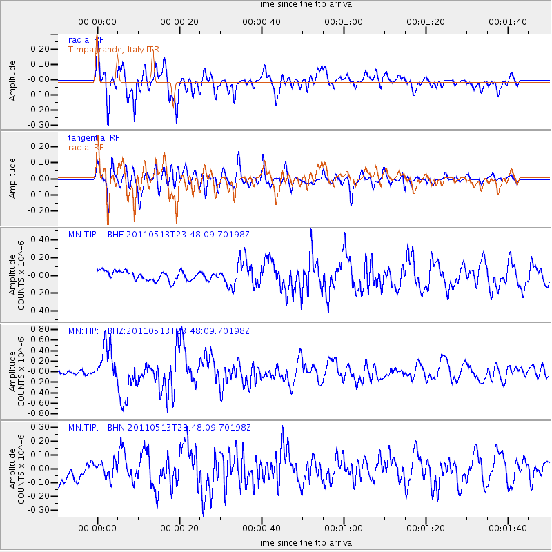
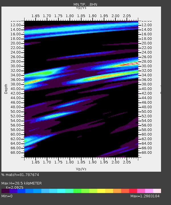
Earthquake location: Near East Coast Of Honshu, Japan
Earthquake latitude/longitude: 37.4/141.3
Earthquake time(UTC): 2011/05/13 (133) 23:35:52 GMT
Earthquake Depth: 35 km
Earthquake Magnitude: 5.6 MB, 5.7 MS, 6.1 MW, 5.9 MW
Earthquake Catalog/Contributor: WHDF/NEIC
Network: MN MEDNET Project
Station: TIP Timpagrande, Italy
Lat/Lon: 39.18 N/16.76 E
Elevation: 789 m
Distance: 88.3 deg
Az: 320.195 deg
Baz: 40.994 deg
Ray Param: 0.042621158
Estimated Moho Depth: 28.5 km
Estimated Crust Vp/Vs: 2.09
Assumed Crust Vp: 6.1 km/s
Estimated Crust Vs: 2.915 km/s
Estimated Crust Poisson's Ratio: 0.35
Radial Match: 81.787674 %
Radial Bump: 400
Transverse Match: 74.17293 %
Transverse Bump: 400
SOD ConfigId: 390285
Insert Time: 2011-10-18 09:14:56.720 +0000
GWidth: 2.5
Max Bumps: 400
Tol: 0.001

Signal To Noise

ChannelStoNSTALTA
MN:TIP: :BHZ:20110513T23:48:09.70198Z6.86084563.5422053E-75.1629282E-8
MN:TIP: :BHN:20110513T23:48:09.70198Z0.87024325.5226877E-86.346143E-8
MN:TIP: :BHE:20110513T23:48:09.70198Z2.28856521.17637114E-75.140213E-8
Arrivals
Ps5.2 SECOND
PpPs14 SECOND
PsPs/PpSs19 SECOND