You are here: Home > Network List > TA - USArray Transportable Network (new EarthScope stations) Stations List
> Station W54A Cherokee Point, Campobello, SC, USA > Earthquake Result Viewer
W54A Cherokee Point, Campobello, SC, USA - Earthquake Result Viewer
*The percent match for this event was below the threshold and hence no stack was calculated.
| Earthquake location: |
Near Coast Of Northern Chile |
| Earthquake latitude/longitude: |
-20.0/-70.9 |
| Earthquake time(UTC): |
2014/03/17 (076) 05:11:34 GMT |
| Earthquake Depth: |
17 km |
| Earthquake Magnitude: |
6.2 MWW, 6.2 MWB, 6.5 MWC |
| Earthquake Catalog/Contributor: |
NEIC PDE/NEIC COMCAT |
|
| Network: |
TA USArray Transportable Network (new EarthScope stations) |
| Station: |
W54A Cherokee Point, Campobello, SC, USA |
| Lat/Lon: |
35.09 N/82.19 W |
| Elevation: |
272 m |
|
| Distance: |
55.8 deg |
| Az: |
348.789 deg |
| Baz: |
167.118 deg |
| Ray Param: |
$rayparam |
*The percent match for this event was below the threshold and hence was not used in the summary stack. |
|
| Radial Match: |
73.75274 % |
| Radial Bump: |
400 |
| Transverse Match: |
54.7648 % |
| Transverse Bump: |
400 |
| SOD ConfigId: |
3390531 |
| Insert Time: |
2019-04-10 17:13:45.655 +0000 |
| GWidth: |
2.5 |
| Max Bumps: |
400 |
| Tol: |
0.001 |
|
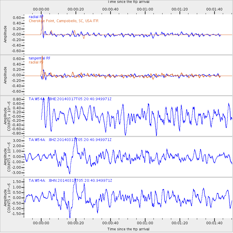
Signal To Noise
| Channel | StoN | STA | LTA |
| TA:W54A: :BHZ:20140317T05:20:40.949971Z | 0.7589442 | 3.4617676E-7 | 4.5612938E-7 |
| TA:W54A: :BHN:20140317T05:20:40.949971Z | 0.9864707 | 3.474628E-7 | 3.5222817E-7 |
| TA:W54A: :BHE:20140317T05:20:40.949971Z | 0.7210461 | 2.4173332E-7 | 3.3525362E-7 |
| Arrivals |
| Ps | |
| PpPs | |
| PsPs/PpSs | |


