You are here: Home > Network List > TA - USArray Transportable Network (new EarthScope stations) Stations List
> Station H29A Onida, SD, USA > Earthquake Result Viewer
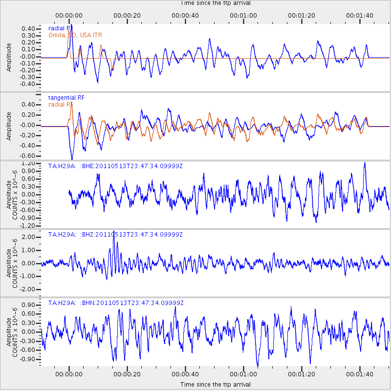
H29A Onida, SD, USA - Earthquake Result Viewer
*The percent match for this event was below the threshold and hence no stack was calculated.
| Earthquake location: |
Near East Coast Of Honshu, Japan |
| Earthquake latitude/longitude: |
37.4/141.3 |
| Earthquake time(UTC): |
2011/05/13 (133) 23:35:52 GMT |
| Earthquake Depth: |
35 km |
| Earthquake Magnitude: |
5.6 MB, 5.7 MS, 6.1 MW, 5.9 MW |
| Earthquake Catalog/Contributor: |
WHDF/NEIC |
|
| Network: |
TA USArray Transportable Network (new EarthScope stations) |
| Station: |
H29A Onida, SD, USA |
| Lat/Lon: |
44.63 N/100.21 W |
| Elevation: |
548 m |
|
| Distance: |
81.2 deg |
| Az: |
39.44 deg |
| Baz: |
314.883 deg |
| Ray Param: |
$rayparam |
*The percent match for this event was below the threshold and hence was not used in the summary stack. |
|
| Radial Match: |
56.8199 % |
| Radial Bump: |
400 |
| Transverse Match: |
72.02491 % |
| Transverse Bump: |
391 |
| SOD ConfigId: |
390285 |
| Insert Time: |
2011-10-18 09:20:56.227 +0000 |
| GWidth: |
2.5 |
| Max Bumps: |
400 |
| Tol: |
0.001 |
|
Signal To Noise
| Channel | StoN | STA | LTA |
| TA:H29A: :BHZ:20110513T23:47:34.09999Z | 2.8586228 | 4.171126E-7 | 1.4591383E-7 |
| TA:H29A: :BHN:20110513T23:47:34.09999Z | 0.96394885 | 2.5117353E-7 | 2.6056728E-7 |
| TA:H29A: :BHE:20110513T23:47:34.09999Z | 0.9997675 | 2.7165288E-7 | 2.7171606E-7 |
| Arrivals |
| Ps | |
| PpPs | |
| PsPs/PpSs | |


