You are here: Home > Network List > TA - USArray Transportable Network (new EarthScope stations) Stations List
> Station 336A Riesel, TX, USA > Earthquake Result Viewer
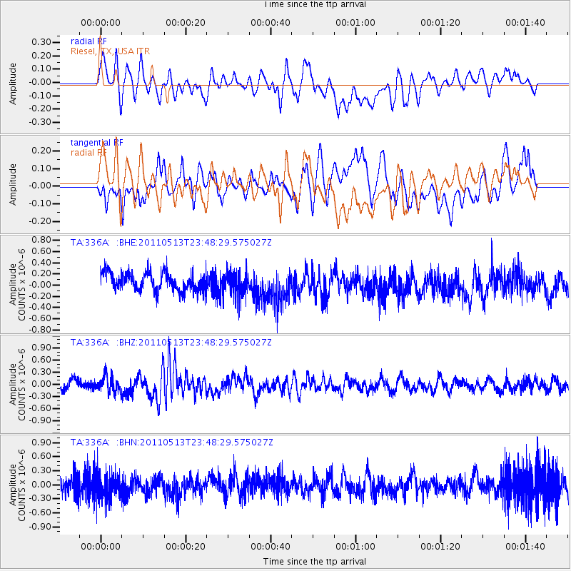
336A Riesel, TX, USA - Earthquake Result Viewer
*The percent match for this event was below the threshold and hence no stack was calculated.
| Earthquake location: |
Near East Coast Of Honshu, Japan |
| Earthquake latitude/longitude: |
37.4/141.3 |
| Earthquake time(UTC): |
2011/05/13 (133) 23:35:52 GMT |
| Earthquake Depth: |
35 km |
| Earthquake Magnitude: |
5.6 MB, 5.7 MS, 6.1 MW, 5.9 MW |
| Earthquake Catalog/Contributor: |
WHDF/NEIC |
|
| Network: |
TA USArray Transportable Network (new EarthScope stations) |
| Station: |
336A Riesel, TX, USA |
| Lat/Lon: |
31.39 N/96.84 W |
| Elevation: |
140 m |
|
| Distance: |
92.6 deg |
| Az: |
46.676 deg |
| Baz: |
317.354 deg |
| Ray Param: |
$rayparam |
*The percent match for this event was below the threshold and hence was not used in the summary stack. |
|
| Radial Match: |
47.827034 % |
| Radial Bump: |
400 |
| Transverse Match: |
43.17288 % |
| Transverse Bump: |
400 |
| SOD ConfigId: |
390285 |
| Insert Time: |
2011-10-18 09:22:35.125 +0000 |
| GWidth: |
2.5 |
| Max Bumps: |
400 |
| Tol: |
0.001 |
|
Signal To Noise
| Channel | StoN | STA | LTA |
| TA:336A: :BHZ:20110513T23:48:29.575027Z | 2.0223851 | 1.9515741E-7 | 9.649864E-8 |
| TA:336A: :BHN:20110513T23:48:29.575027Z | 1.9164973 | 2.7530163E-7 | 1.4364832E-7 |
| TA:336A: :BHE:20110513T23:48:29.575027Z | 1.3663235 | 2.2141572E-7 | 1.6205219E-7 |
| Arrivals |
| Ps | |
| PpPs | |
| PsPs/PpSs | |


