You are here: Home > Network List > TA - USArray Transportable Network (new EarthScope stations) Stations List
> Station G35A Watkins, MN, USA > Earthquake Result Viewer
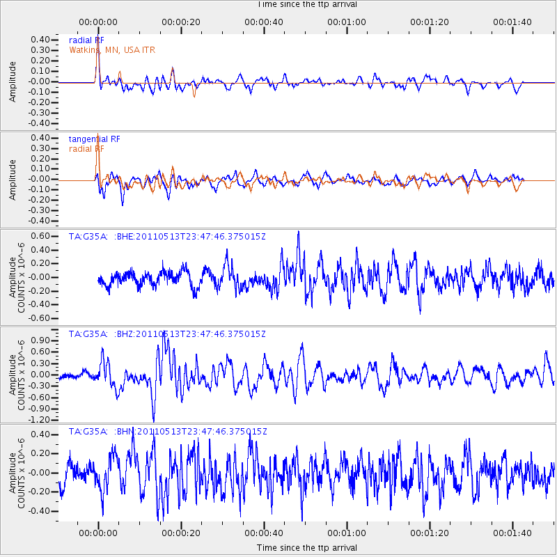
G35A Watkins, MN, USA - Earthquake Result Viewer
*The percent match for this event was below the threshold and hence no stack was calculated.
| Earthquake location: |
Near East Coast Of Honshu, Japan |
| Earthquake latitude/longitude: |
37.4/141.3 |
| Earthquake time(UTC): |
2011/05/13 (133) 23:35:52 GMT |
| Earthquake Depth: |
35 km |
| Earthquake Magnitude: |
5.6 MB, 5.7 MS, 6.1 MW, 5.9 MW |
| Earthquake Catalog/Contributor: |
WHDF/NEIC |
|
| Network: |
TA USArray Transportable Network (new EarthScope stations) |
| Station: |
G35A Watkins, MN, USA |
| Lat/Lon: |
45.22 N/94.49 W |
| Elevation: |
361 m |
|
| Distance: |
83.6 deg |
| Az: |
36.045 deg |
| Baz: |
318.467 deg |
| Ray Param: |
$rayparam |
*The percent match for this event was below the threshold and hence was not used in the summary stack. |
|
| Radial Match: |
59.88931 % |
| Radial Bump: |
400 |
| Transverse Match: |
62.07843 % |
| Transverse Bump: |
400 |
| SOD ConfigId: |
390285 |
| Insert Time: |
2011-10-18 09:26:36.424 +0000 |
| GWidth: |
2.5 |
| Max Bumps: |
400 |
| Tol: |
0.001 |
|
Signal To Noise
| Channel | StoN | STA | LTA |
| TA:G35A: :BHZ:20110513T23:47:46.375015Z | 5.1421084 | 3.5020054E-7 | 6.810446E-8 |
| TA:G35A: :BHN:20110513T23:47:46.375015Z | 1.4266342 | 1.8017249E-7 | 1.2629201E-7 |
| TA:G35A: :BHE:20110513T23:47:46.375015Z | 1.6835577 | 1.6967003E-7 | 1.00780646E-7 |
| Arrivals |
| Ps | |
| PpPs | |
| PsPs/PpSs | |


