You are here: Home > Network List > TA - USArray Transportable Network (new EarthScope stations) Stations List
> Station C39A Grand Marais, MN, USA > Earthquake Result Viewer
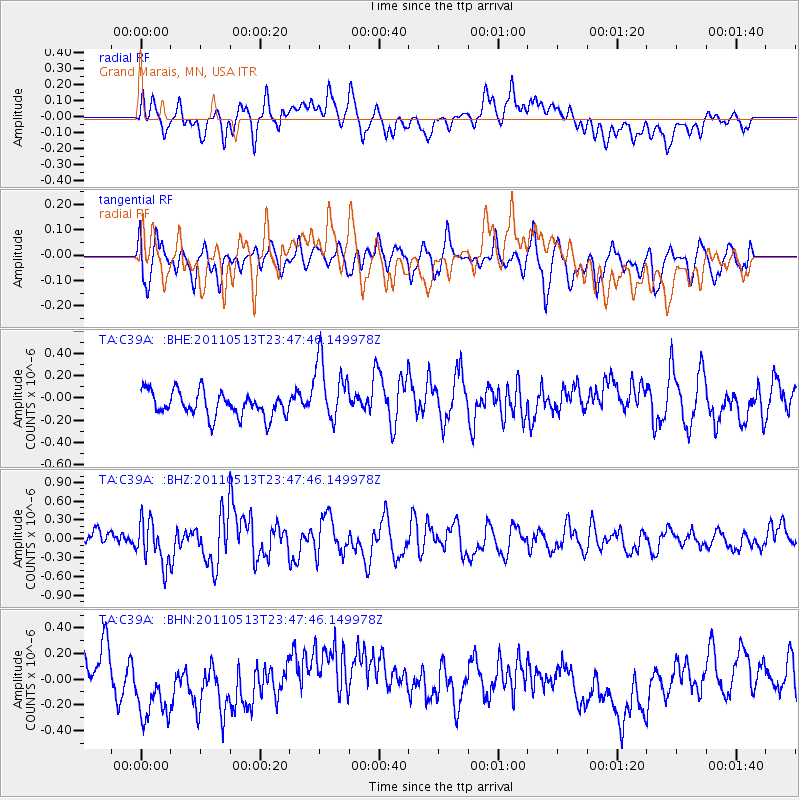
C39A Grand Marais, MN, USA - Earthquake Result Viewer
*The percent match for this event was below the threshold and hence no stack was calculated.
| Earthquake location: |
Near East Coast Of Honshu, Japan |
| Earthquake latitude/longitude: |
37.4/141.3 |
| Earthquake time(UTC): |
2011/05/13 (133) 23:35:52 GMT |
| Earthquake Depth: |
35 km |
| Earthquake Magnitude: |
5.6 MB, 5.7 MS, 6.1 MW, 5.9 MW |
| Earthquake Catalog/Contributor: |
WHDF/NEIC |
|
| Network: |
TA USArray Transportable Network (new EarthScope stations) |
| Station: |
C39A Grand Marais, MN, USA |
| Lat/Lon: |
47.82 N/90.13 W |
| Elevation: |
341 m |
|
| Distance: |
83.5 deg |
| Az: |
32.046 deg |
| Baz: |
321.171 deg |
| Ray Param: |
$rayparam |
*The percent match for this event was below the threshold and hence was not used in the summary stack. |
|
| Radial Match: |
46.395523 % |
| Radial Bump: |
400 |
| Transverse Match: |
59.35916 % |
| Transverse Bump: |
400 |
| SOD ConfigId: |
390285 |
| Insert Time: |
2011-10-18 09:27:07.298 +0000 |
| GWidth: |
2.5 |
| Max Bumps: |
400 |
| Tol: |
0.001 |
|
Signal To Noise
| Channel | StoN | STA | LTA |
| TA:C39A: :BHZ:20110513T23:47:46.149978Z | 2.4944665 | 3.4475028E-7 | 1.38206E-7 |
| TA:C39A: :BHN:20110513T23:47:46.149978Z | 1.3482687 | 2.4965004E-7 | 1.851634E-7 |
| TA:C39A: :BHE:20110513T23:47:46.149978Z | 2.598031 | 2.846127E-7 | 1.0954938E-7 |
| Arrivals |
| Ps | |
| PpPs | |
| PsPs/PpSs | |


