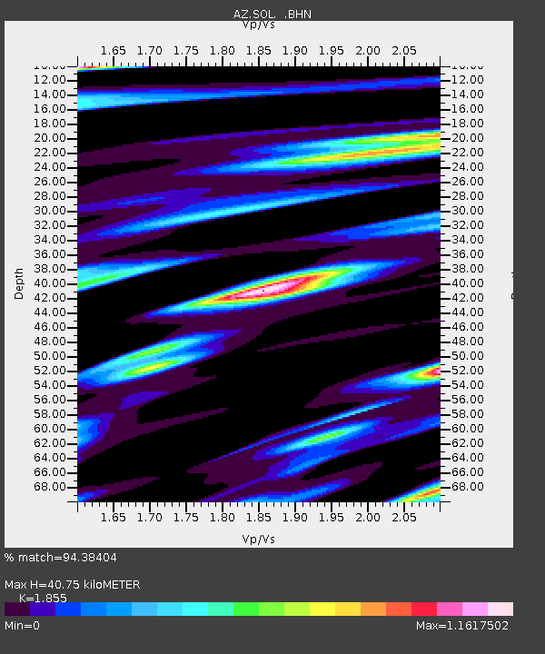
SOL AZ.SOL - Earthquake Result Viewer

Earthquake location: New Britain Region, P.N.G.
Earthquake latitude/longitude: -5.5/151.8
Earthquake time(UTC): 2000/11/17 (322) 21:01:56 GMT
Earthquake Depth: 33 km
Earthquake Magnitude: 6.2 MB, 8.0 MS, 7.6 MW, 6.9 ME
Earthquake Catalog/Contributor: WHDF/NEIC
Network: AZ ANZA Regional Network
Station: SOL AZ.SOL
Lat/Lon: 32.84 N/117.25 W
Elevation: 245 m
Distance: 93.8 deg
Az: 57.514 deg
Baz: 265.92 deg
Ray Param: 0.041186452
Estimated Moho Depth: 40.75 km
Estimated Crust Vp/Vs: 1.86
Assumed Crust Vp: 6.264 km/s
Estimated Crust Vs: 3.377 km/s
Estimated Crust Poisson's Ratio: 0.30
Radial Match: 94.38404 %
Radial Bump: 366
Transverse Match: 88.32998 %
Transverse Bump: 400
SOD ConfigId: 3744
Insert Time: 2010-02-26 21:06:22.279 +0000
GWidth: 2.5
Max Bumps: 400
Tol: 0.001

Signal To Noise

ChannelStoNSTALTA
AZ:SOL: :BHN:20001117T21:14:38.674021Z1.15327192.016599E-61.7485894E-6
AZ:SOL: :BHE:20001117T21:14:38.674021Z1.51827692.3828713E-61.5694577E-6
AZ:SOL: :BHZ:20001117T21:14:38.674021Z1.4216891.6217059E-61.1406896E-6
Arrivals
Ps5.7 SECOND
PpPs18 SECOND
PsPs/PpSs24 SECOND