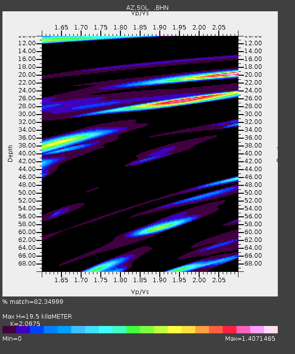
SOL AZ.SOL - Earthquake Result Viewer
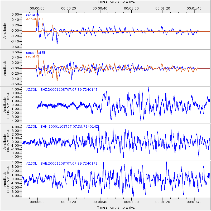
Earthquake location: Panama-Colombia Border Region
Earthquake latitude/longitude: 7.0/-77.8
Earthquake time(UTC): 2000/11/08 (313) 06:59:58 GMT
Earthquake Depth: 17 km
Earthquake Magnitude: 6.0 MB, 6.4 MS, 6.5 MW, 6.2 ML
Earthquake Catalog/Contributor: WHDF/NEIC
Network: AZ ANZA Regional Network
Station: SOL AZ.SOL
Lat/Lon: 32.84 N/117.25 W
Elevation: 245 m
Distance: 44.7 deg
Az: 310.498 deg
Baz: 116.288 deg
Ray Param: 0.07175895
Estimated Moho Depth: 19.5 km
Estimated Crust Vp/Vs: 2.10
Assumed Crust Vp: 6.264 km/s
Estimated Crust Vs: 2.986 km/s
Estimated Crust Poisson's Ratio: 0.35
Radial Match: 82.34999 %
Radial Bump: 400
Transverse Match: 85.679344 %
Transverse Bump: 400
SOD ConfigId: 3744
Insert Time: 2010-02-26 21:06:33.883 +0000
GWidth: 2.5
Max Bumps: 400
Tol: 0.001

Signal To Noise

ChannelStoNSTALTA
AZ:SOL: :BHN:20001108T07:07:39.724014Z1.15981966.362324E-75.4856156E-7
AZ:SOL: :BHE:20001108T07:07:39.724014Z0.949340055.858597E-76.1712313E-7
AZ:SOL: :BHZ:20001108T07:07:39.724014Z1.56335335.304679E-73.3931417E-7
Arrivals
Ps3.6 SECOND
PpPs9.2 SECOND
PsPs/PpSs13 SECOND