You are here: Home > Network List > IU - Global Seismograph Network (GSN - IRIS/USGS) Stations List
> Station XMAS Kiritimati Island, Republic of Kiribati > Earthquake Result Viewer
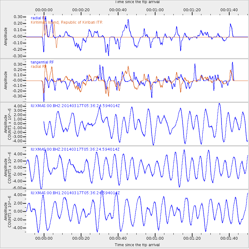
XMAS Kiritimati Island, Republic of Kiribati - Earthquake Result Viewer
*The percent match for this event was below the threshold and hence no stack was calculated.
| Earthquake location: |
Near Coast Of Northern Chile |
| Earthquake latitude/longitude: |
-20.1/-70.8 |
| Earthquake time(UTC): |
2014/03/17 (076) 05:24:07 GMT |
| Earthquake Depth: |
10 km |
| Earthquake Magnitude: |
4.6 mb |
| Earthquake Catalog/Contributor: |
ISC/ISC |
|
| Network: |
IU Global Seismograph Network (GSN - IRIS/USGS) |
| Station: |
XMAS Kiritimati Island, Republic of Kiribati |
| Lat/Lon: |
2.04 N/157.45 W |
| Elevation: |
20 m |
|
| Distance: |
87.6 deg |
| Az: |
273.046 deg |
| Baz: |
110.097 deg |
| Ray Param: |
$rayparam |
*The percent match for this event was below the threshold and hence was not used in the summary stack. |
|
| Radial Match: |
56.352715 % |
| Radial Bump: |
400 |
| Transverse Match: |
67.40502 % |
| Transverse Bump: |
400 |
| SOD ConfigId: |
3390531 |
| Insert Time: |
2019-04-10 17:18:17.722 +0000 |
| GWidth: |
2.5 |
| Max Bumps: |
400 |
| Tol: |
0.001 |
|
Signal To Noise
| Channel | StoN | STA | LTA |
| IU:XMAS:00:BHZ:20140317T05:36:24.594014Z | 1.1974852 | 2.8670688E-6 | 2.3942414E-6 |
| IU:XMAS:00:BH1:20140317T05:36:24.594014Z | 1.9467691 | 3.2856642E-6 | 1.6877524E-6 |
| IU:XMAS:00:BH2:20140317T05:36:24.594014Z | 1.5442683 | 2.3418695E-6 | 1.5164914E-6 |
| Arrivals |
| Ps | |
| PpPs | |
| PsPs/PpSs | |


