You are here: Home > Network List > OE - Austrian Seismic Network Stations List
> Station KBA Koelnbreinsperre, Kaernten, Austria > Earthquake Result Viewer
KBA Koelnbreinsperre, Kaernten, Austria - Earthquake Result Viewer
| Earthquake location: |
Hindu Kush Region, Afghanistan |
| Earthquake latitude/longitude: |
36.4/70.7 |
| Earthquake time(UTC): |
2011/05/14 (134) 21:07:22 GMT |
| Earthquake Depth: |
207 km |
| Earthquake Magnitude: |
5.8 MB, 6.0 MW, 6.0 MW |
| Earthquake Catalog/Contributor: |
WHDF/NEIC |
|
| Network: |
OE Austrian Seismic Network |
| Station: |
KBA Koelnbreinsperre, Kaernten, Austria |
| Lat/Lon: |
47.08 N/13.34 E |
| Elevation: |
1721 m |
|
| Distance: |
43.2 deg |
| Az: |
302.816 deg |
| Baz: |
82.735 deg |
| Ray Param: |
0.071861915 |
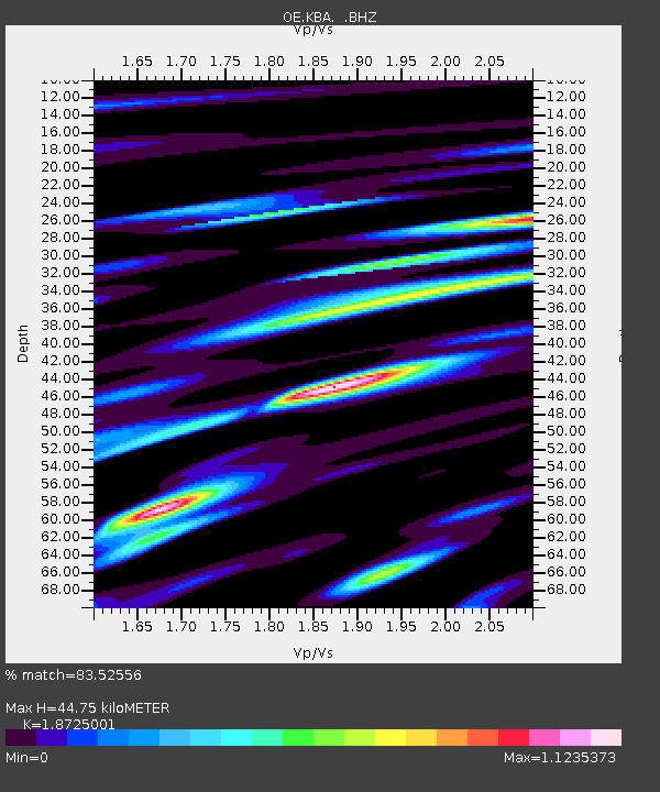
| Estimated Moho Depth: |
44.75 km |
| Estimated Crust Vp/Vs: |
1.87 |
| Assumed Crust Vp: |
6.35 km/s |
| Estimated Crust Vs: |
3.391 km/s |
| Estimated Crust Poisson's Ratio: |
0.30 |
|
| Radial Match: |
83.52556 % |
| Radial Bump: |
400 |
| Transverse Match: |
81.15675 % |
| Transverse Bump: |
400 |
| SOD ConfigId: |
391883 |
| Insert Time: |
2011-10-22 23:27:12.763 +0000 |
| GWidth: |
2.5 |
| Max Bumps: |
400 |
| Tol: |
0.001 |
|

Signal To Noise
| Channel | StoN | STA | LTA |
| OE:KBA: :BHZ:20110514T21:14:32.411007Z | 22.323187 | 8.7386115E-7 | 3.91459E-8 |
| OE:KBA: :BHN:20110514T21:14:32.411007Z | 7.489797 | 1.7123328E-7 | 2.2862206E-8 |
| OE:KBA: :BHE:20110514T21:14:32.411007Z | 16.696003 | 6.0129105E-7 | 3.601407E-8 |
| Arrivals |
| Ps | 6.5 SECOND |
| PpPs | 19 SECOND |
| PsPs/PpSs | 26 SECOND |


