You are here: Home > Network List > TA - USArray Transportable Network (new EarthScope stations) Stations List
> Station N60A Cedar Hill Farm, Mount Bethel, PA, USA > Earthquake Result Viewer
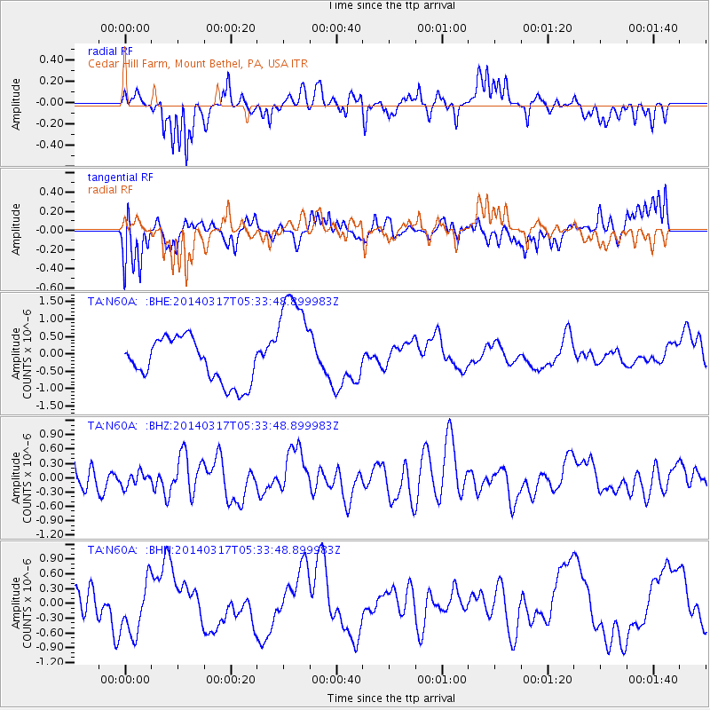
N60A Cedar Hill Farm, Mount Bethel, PA, USA - Earthquake Result Viewer
*The percent match for this event was below the threshold and hence no stack was calculated.
| Earthquake location: |
Near Coast Of Northern Chile |
| Earthquake latitude/longitude: |
-20.1/-70.8 |
| Earthquake time(UTC): |
2014/03/17 (076) 05:24:07 GMT |
| Earthquake Depth: |
10 km |
| Earthquake Magnitude: |
4.6 mb |
| Earthquake Catalog/Contributor: |
ISC/ISC |
|
| Network: |
TA USArray Transportable Network (new EarthScope stations) |
| Station: |
N60A Cedar Hill Farm, Mount Bethel, PA, USA |
| Lat/Lon: |
40.87 N/75.10 W |
| Elevation: |
189 m |
|
| Distance: |
60.8 deg |
| Az: |
356.237 deg |
| Baz: |
175.335 deg |
| Ray Param: |
$rayparam |
*The percent match for this event was below the threshold and hence was not used in the summary stack. |
|
| Radial Match: |
62.726143 % |
| Radial Bump: |
400 |
| Transverse Match: |
39.593563 % |
| Transverse Bump: |
394 |
| SOD ConfigId: |
3390531 |
| Insert Time: |
2019-04-10 17:20:46.863 +0000 |
| GWidth: |
2.5 |
| Max Bumps: |
400 |
| Tol: |
0.001 |
|
Signal To Noise
| Channel | StoN | STA | LTA |
| TA:N60A: :BHZ:20140317T05:33:48.899983Z | 0.5234314 | 1.4703797E-7 | 2.8091162E-7 |
| TA:N60A: :BHN:20140317T05:33:48.899983Z | 2.167302 | 5.563689E-7 | 2.567104E-7 |
| TA:N60A: :BHE:20140317T05:33:48.899983Z | 2.5148253 | 1.574808E-6 | 6.2620967E-7 |
| Arrivals |
| Ps | |
| PpPs | |
| PsPs/PpSs | |


