You are here: Home > Network List > TA - USArray Transportable Network (new EarthScope stations) Stations List
> Station E31A Nome, ND, USA > Earthquake Result Viewer
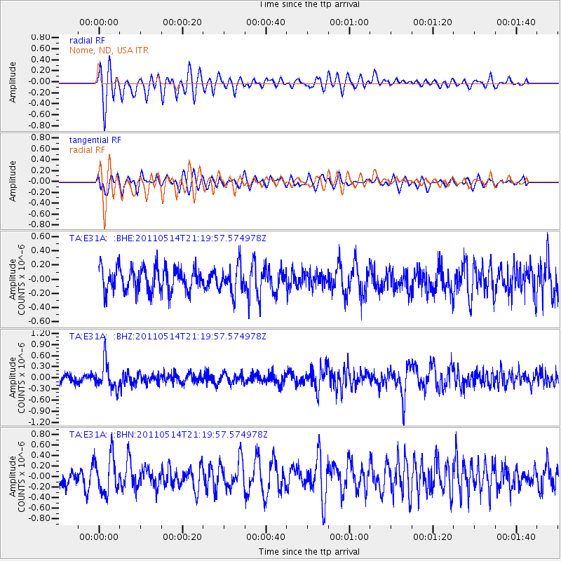
E31A Nome, ND, USA - Earthquake Result Viewer
*The percent match for this event was below the threshold and hence no stack was calculated.
| Earthquake location: |
Hindu Kush Region, Afghanistan |
| Earthquake latitude/longitude: |
36.4/70.7 |
| Earthquake time(UTC): |
2011/05/14 (134) 21:07:22 GMT |
| Earthquake Depth: |
207 km |
| Earthquake Magnitude: |
5.8 MB, 6.0 MW, 6.0 MW |
| Earthquake Catalog/Contributor: |
WHDF/NEIC |
|
| Network: |
TA USArray Transportable Network (new EarthScope stations) |
| Station: |
E31A Nome, ND, USA |
| Lat/Lon: |
46.56 N/97.89 W |
| Elevation: |
427 m |
|
| Distance: |
96.8 deg |
| Az: |
352.13 deg |
| Baz: |
9.211 deg |
| Ray Param: |
$rayparam |
*The percent match for this event was below the threshold and hence was not used in the summary stack. |
|
| Radial Match: |
60.95591 % |
| Radial Bump: |
400 |
| Transverse Match: |
51.33043 % |
| Transverse Bump: |
400 |
| SOD ConfigId: |
391883 |
| Insert Time: |
2011-10-22 23:30:46.690 +0000 |
| GWidth: |
2.5 |
| Max Bumps: |
400 |
| Tol: |
0.001 |
|
Signal To Noise
| Channel | StoN | STA | LTA |
| TA:E31A: :BHZ:20110514T21:19:57.574978Z | 2.9259338 | 3.7074275E-7 | 1.2670921E-7 |
| TA:E31A: :BHN:20110514T21:19:57.574978Z | 2.0608094 | 3.430548E-7 | 1.6646607E-7 |
| TA:E31A: :BHE:20110514T21:19:57.574978Z | 1.171209 | 1.9683023E-7 | 1.6805731E-7 |
| Arrivals |
| Ps | |
| PpPs | |
| PsPs/PpSs | |


