You are here: Home > Network List > TA - USArray Transportable Network (new EarthScope stations) Stations List
> Station D36A Goodland, MN, USA > Earthquake Result Viewer
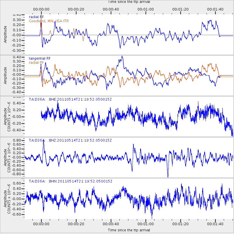
D36A Goodland, MN, USA - Earthquake Result Viewer
*The percent match for this event was below the threshold and hence no stack was calculated.
| Earthquake location: |
Hindu Kush Region, Afghanistan |
| Earthquake latitude/longitude: |
36.4/70.7 |
| Earthquake time(UTC): |
2011/05/14 (134) 21:07:22 GMT |
| Earthquake Depth: |
207 km |
| Earthquake Magnitude: |
5.8 MB, 6.0 MW, 6.0 MW |
| Earthquake Catalog/Contributor: |
WHDF/NEIC |
|
| Network: |
TA USArray Transportable Network (new EarthScope stations) |
| Station: |
D36A Goodland, MN, USA |
| Lat/Lon: |
47.18 N/93.16 W |
| Elevation: |
434 m |
|
| Distance: |
95.5 deg |
| Az: |
349.051 deg |
| Baz: |
12.979 deg |
| Ray Param: |
$rayparam |
*The percent match for this event was below the threshold and hence was not used in the summary stack. |
|
| Radial Match: |
48.75656 % |
| Radial Bump: |
400 |
| Transverse Match: |
46.3671 % |
| Transverse Bump: |
400 |
| SOD ConfigId: |
391883 |
| Insert Time: |
2011-10-22 23:31:49.836 +0000 |
| GWidth: |
2.5 |
| Max Bumps: |
400 |
| Tol: |
0.001 |
|
Signal To Noise
| Channel | StoN | STA | LTA |
| TA:D36A: :BHZ:20110514T21:19:52.050015Z | 2.7736783 | 3.1854526E-7 | 1.1484578E-7 |
| TA:D36A: :BHN:20110514T21:19:52.050015Z | 1.4865873 | 2.2441071E-7 | 1.5095698E-7 |
| TA:D36A: :BHE:20110514T21:19:52.050015Z | 2.1499624 | 2.404875E-7 | 1.118566E-7 |
| Arrivals |
| Ps | |
| PpPs | |
| PsPs/PpSs | |


