You are here: Home > Network List > UW - Pacific Northwest Regional Seismic Network Stations List
> Station MRBL Marblemount, WA, USA > Earthquake Result Viewer
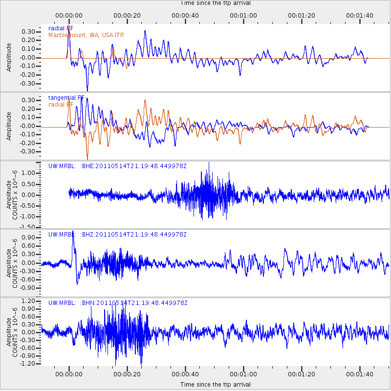
MRBL Marblemount, WA, USA - Earthquake Result Viewer
*The percent match for this event was below the threshold and hence no stack was calculated.
| Earthquake location: |
Hindu Kush Region, Afghanistan |
| Earthquake latitude/longitude: |
36.4/70.7 |
| Earthquake time(UTC): |
2011/05/14 (134) 21:07:22 GMT |
| Earthquake Depth: |
207 km |
| Earthquake Magnitude: |
5.8 MB, 6.0 MW, 6.0 MW |
| Earthquake Catalog/Contributor: |
WHDF/NEIC |
|
| Network: |
UW Pacific Northwest Regional Seismic Network |
| Station: |
MRBL Marblemount, WA, USA |
| Lat/Lon: |
48.52 N/121.48 W |
| Elevation: |
75 m |
|
| Distance: |
94.7 deg |
| Az: |
8.126 deg |
| Baz: |
350.124 deg |
| Ray Param: |
$rayparam |
*The percent match for this event was below the threshold and hence was not used in the summary stack. |
|
| Radial Match: |
59.43724 % |
| Radial Bump: |
400 |
| Transverse Match: |
56.04572 % |
| Transverse Bump: |
400 |
| SOD ConfigId: |
391883 |
| Insert Time: |
2011-10-22 23:34:07.506 +0000 |
| GWidth: |
2.5 |
| Max Bumps: |
400 |
| Tol: |
0.001 |
|
Signal To Noise
| Channel | StoN | STA | LTA |
| UW:MRBL: :BHZ:20110514T21:19:48.449978Z | 6.6893563 | 4.3551725E-7 | 6.5106E-8 |
| UW:MRBL: :BHN:20110514T21:19:48.449978Z | 1.8814592 | 2.2326988E-7 | 1.1866847E-7 |
| UW:MRBL: :BHE:20110514T21:19:48.449978Z | 1.5176356 | 1.8283849E-7 | 1.2047589E-7 |
| Arrivals |
| Ps | |
| PpPs | |
| PsPs/PpSs | |


