You are here: Home > Network List > TA - USArray Transportable Network (new EarthScope stations) Stations List
> Station U61A Possum Corner Farms, Belvidere, NC, USA > Earthquake Result Viewer
U61A Possum Corner Farms, Belvidere, NC, USA - Earthquake Result Viewer
| Earthquake location: |
Near Coast Of Northern Chile |
| Earthquake latitude/longitude: |
-20.1/-70.8 |
| Earthquake time(UTC): |
2014/03/17 (076) 05:24:07 GMT |
| Earthquake Depth: |
10 km |
| Earthquake Magnitude: |
4.6 mb |
| Earthquake Catalog/Contributor: |
ISC/ISC |
|
| Network: |
TA USArray Transportable Network (new EarthScope stations) |
| Station: |
U61A Possum Corner Farms, Belvidere, NC, USA |
| Lat/Lon: |
36.33 N/76.45 W |
| Elevation: |
4.0 m |
|
| Distance: |
56.4 deg |
| Az: |
354.494 deg |
| Baz: |
173.588 deg |
| Ray Param: |
0.064180575 |
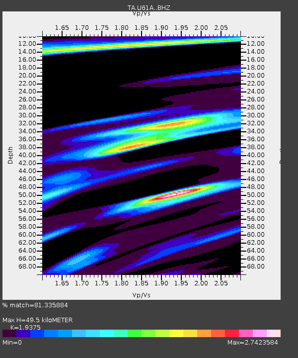
| Estimated Moho Depth: |
49.5 km |
| Estimated Crust Vp/Vs: |
1.94 |
| Assumed Crust Vp: |
6.565 km/s |
| Estimated Crust Vs: |
3.388 km/s |
| Estimated Crust Poisson's Ratio: |
0.32 |
|
| Radial Match: |
81.335884 % |
| Radial Bump: |
400 |
| Transverse Match: |
63.28753 % |
| Transverse Bump: |
400 |
| SOD ConfigId: |
3390531 |
| Insert Time: |
2019-04-10 17:21:21.553 +0000 |
| GWidth: |
2.5 |
| Max Bumps: |
400 |
| Tol: |
0.001 |
|

Signal To Noise
| Channel | StoN | STA | LTA |
| TA:U61A: :BHZ:20140317T05:33:18.25002Z | 2.1220717 | 5.613405E-6 | 2.6452474E-6 |
| TA:U61A: :BHN:20140317T05:33:18.25002Z | 2.019055 | 1.1381164E-5 | 5.6368767E-6 |
| TA:U61A: :BHE:20140317T05:33:18.25002Z | 0.8890645 | 3.4431691E-6 | 3.8728003E-6 |
| Arrivals |
| Ps | 7.4 SECOND |
| PpPs | 21 SECOND |
| PsPs/PpSs | 29 SECOND |


