You are here: Home > Network List > KN - Kyrgyz Seismic Telemetry Network Stations List
> Station TKM2 KN.TKM2 > Earthquake Result Viewer
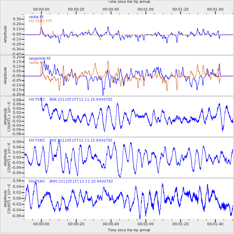
TKM2 KN.TKM2 - Earthquake Result Viewer
*The percent match for this event was below the threshold and hence no stack was calculated.
| Earthquake location: |
Central Mid-Atlantic Ridge |
| Earthquake latitude/longitude: |
0.6/-25.6 |
| Earthquake time(UTC): |
2011/05/15 (135) 13:08:13 GMT |
| Earthquake Depth: |
10 km |
| Earthquake Magnitude: |
5.6 MB, 5.4 MS, 6.1 MW, 6.1 MW |
| Earthquake Catalog/Contributor: |
WHDF/NEIC |
|
| Network: |
KN Kyrgyz Seismic Telemetry Network |
| Station: |
TKM2 KN.TKM2 |
| Lat/Lon: |
42.92 N/75.60 E |
| Elevation: |
2020 m |
|
| Distance: |
97.8 deg |
| Az: |
46.659 deg |
| Baz: |
278.098 deg |
| Ray Param: |
$rayparam |
*The percent match for this event was below the threshold and hence was not used in the summary stack. |
|
| Radial Match: |
36.59439 % |
| Radial Bump: |
400 |
| Transverse Match: |
45.725883 % |
| Transverse Bump: |
400 |
| SOD ConfigId: |
391883 |
| Insert Time: |
2011-10-22 23:45:34.953 +0000 |
| GWidth: |
2.5 |
| Max Bumps: |
400 |
| Tol: |
0.001 |
|
Signal To Noise
| Channel | StoN | STA | LTA |
| KN:TKM2: :BHZ:20110515T13:21:16.849978Z | 1.1710786 | 5.051217E-8 | 4.3133035E-8 |
| KN:TKM2: :BHN:20110515T13:21:16.849978Z | 0.62095207 | 1.5194752E-8 | 2.4470088E-8 |
| KN:TKM2: :BHE:20110515T13:21:16.849978Z | 1.2754356 | 3.1442344E-8 | 2.465224E-8 |
| Arrivals |
| Ps | |
| PpPs | |
| PsPs/PpSs | |


