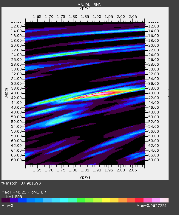
IDI Anogia, Greece - Earthquake Result Viewer

Earthquake location: Central Mid-Atlantic Ridge
Earthquake latitude/longitude: 0.6/-25.6
Earthquake time(UTC): 2011/05/15 (135) 13:08:13 GMT
Earthquake Depth: 10 km
Earthquake Magnitude: 5.6 MB, 5.4 MS, 6.1 MW, 6.1 MW
Earthquake Catalog/Contributor: WHDF/NEIC
Network: MN MEDNET Project
Station: IDI Anogia, Greece
Lat/Lon: 35.29 N/24.89 E
Elevation: 750 m
Distance: 58.3 deg
Az: 47.937 deg
Baz: 245.156 deg
Ray Param: 0.062940225
Estimated Moho Depth: 40.25 km
Estimated Crust Vp/Vs: 1.89
Assumed Crust Vp: 5.627 km/s
Estimated Crust Vs: 2.969 km/s
Estimated Crust Poisson's Ratio: 0.31
Radial Match: 87.901596 %
Radial Bump: 400
Transverse Match: 79.20005 %
Transverse Bump: 400
SOD ConfigId: 391883
Insert Time: 2011-10-22 23:45:50.434 +0000
GWidth: 2.5
Max Bumps: 400
Tol: 0.001

Signal To Noise

ChannelStoNSTALTA
MN:IDI: :BHZ:20110515T13:17:36.786013Z2.05795551.2287035E-75.970506E-8
MN:IDI: :BHN:20110515T13:17:36.786013Z1.01939235.2119194E-85.1127714E-8
MN:IDI: :BHE:20110515T13:17:36.786013Z1.12543275.279098E-84.690727E-8
Arrivals
Ps6.6 SECOND
PpPs20 SECOND
PsPs/PpSs27 SECOND