You are here: Home > Network List > TA - USArray Transportable Network (new EarthScope stations) Stations List
> Station G35A Watkins, MN, USA > Earthquake Result Viewer
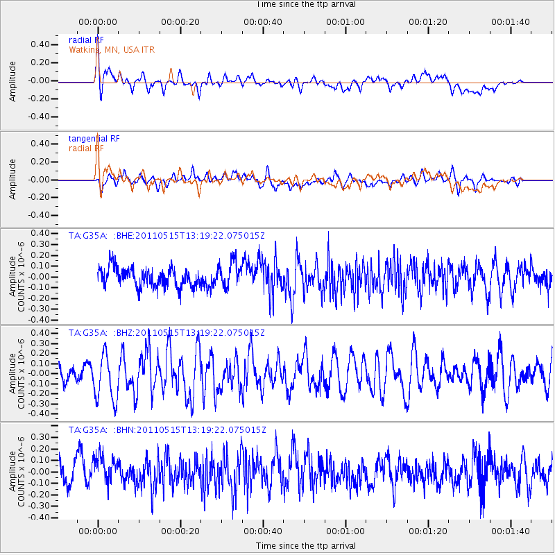
G35A Watkins, MN, USA - Earthquake Result Viewer
*The percent match for this event was below the threshold and hence no stack was calculated.
| Earthquake location: |
Central Mid-Atlantic Ridge |
| Earthquake latitude/longitude: |
0.6/-25.6 |
| Earthquake time(UTC): |
2011/05/15 (135) 13:08:13 GMT |
| Earthquake Depth: |
10 km |
| Earthquake Magnitude: |
5.6 MB, 5.4 MS, 6.1 MW, 6.1 MW |
| Earthquake Catalog/Contributor: |
WHDF/NEIC |
|
| Network: |
TA USArray Transportable Network (new EarthScope stations) |
| Station: |
G35A Watkins, MN, USA |
| Lat/Lon: |
45.22 N/94.49 W |
| Elevation: |
361 m |
|
| Distance: |
74.8 deg |
| Az: |
316.923 deg |
| Baz: |
104.916 deg |
| Ray Param: |
$rayparam |
*The percent match for this event was below the threshold and hence was not used in the summary stack. |
|
| Radial Match: |
62.362823 % |
| Radial Bump: |
400 |
| Transverse Match: |
52.224102 % |
| Transverse Bump: |
400 |
| SOD ConfigId: |
391883 |
| Insert Time: |
2011-10-22 23:49:49.849 +0000 |
| GWidth: |
2.5 |
| Max Bumps: |
400 |
| Tol: |
0.001 |
|
Signal To Noise
| Channel | StoN | STA | LTA |
| TA:G35A: :BHZ:20110515T13:19:22.075015Z | 3.419951 | 2.3398589E-7 | 6.8417904E-8 |
| TA:G35A: :BHN:20110515T13:19:22.075015Z | 1.2520406 | 1.3188883E-7 | 1.0533909E-7 |
| TA:G35A: :BHE:20110515T13:19:22.075015Z | 1.3814601 | 1.17119235E-7 | 8.4779316E-8 |
| Arrivals |
| Ps | |
| PpPs | |
| PsPs/PpSs | |


