You are here: Home > Network List > TA - USArray Transportable Network (new EarthScope stations) Stations List
> Station W40A Ferguson Farm, Pottsville, AR, USA > Earthquake Result Viewer
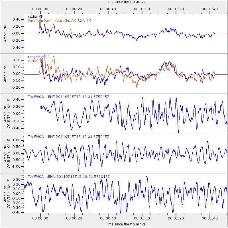
W40A Ferguson Farm, Pottsville, AR, USA - Earthquake Result Viewer
*The percent match for this event was below the threshold and hence no stack was calculated.
| Earthquake location: |
Central Mid-Atlantic Ridge |
| Earthquake latitude/longitude: |
0.6/-25.6 |
| Earthquake time(UTC): |
2011/05/15 (135) 13:08:13 GMT |
| Earthquake Depth: |
10 km |
| Earthquake Magnitude: |
5.6 MB, 5.4 MS, 6.1 MW, 6.1 MW |
| Earthquake Catalog/Contributor: |
WHDF/NEIC |
|
| Network: |
TA USArray Transportable Network (new EarthScope stations) |
| Station: |
W40A Ferguson Farm, Pottsville, AR, USA |
| Lat/Lon: |
35.19 N/93.07 W |
| Elevation: |
108 m |
|
| Distance: |
71.3 deg |
| Az: |
307.035 deg |
| Baz: |
102.943 deg |
| Ray Param: |
$rayparam |
*The percent match for this event was below the threshold and hence was not used in the summary stack. |
|
| Radial Match: |
67.81439 % |
| Radial Bump: |
400 |
| Transverse Match: |
62.395306 % |
| Transverse Bump: |
400 |
| SOD ConfigId: |
391883 |
| Insert Time: |
2011-10-22 23:51:22.255 +0000 |
| GWidth: |
2.5 |
| Max Bumps: |
400 |
| Tol: |
0.001 |
|
Signal To Noise
| Channel | StoN | STA | LTA |
| TA:W40A: :BHZ:20110515T13:19:01.575015Z | 1.8526912 | 3.6538268E-7 | 1.9721725E-7 |
| TA:W40A: :BHN:20110515T13:19:01.575015Z | 1.3799754 | 2.1966773E-7 | 1.5918233E-7 |
| TA:W40A: :BHE:20110515T13:19:01.575015Z | 1.0149744 | 2.1742925E-7 | 2.1422143E-7 |
| Arrivals |
| Ps | |
| PpPs | |
| PsPs/PpSs | |


