You are here: Home > Network List > IW - Intermountain West Stations List
> Station MOOW Moose Ponds, Wyoming, USA > Earthquake Result Viewer
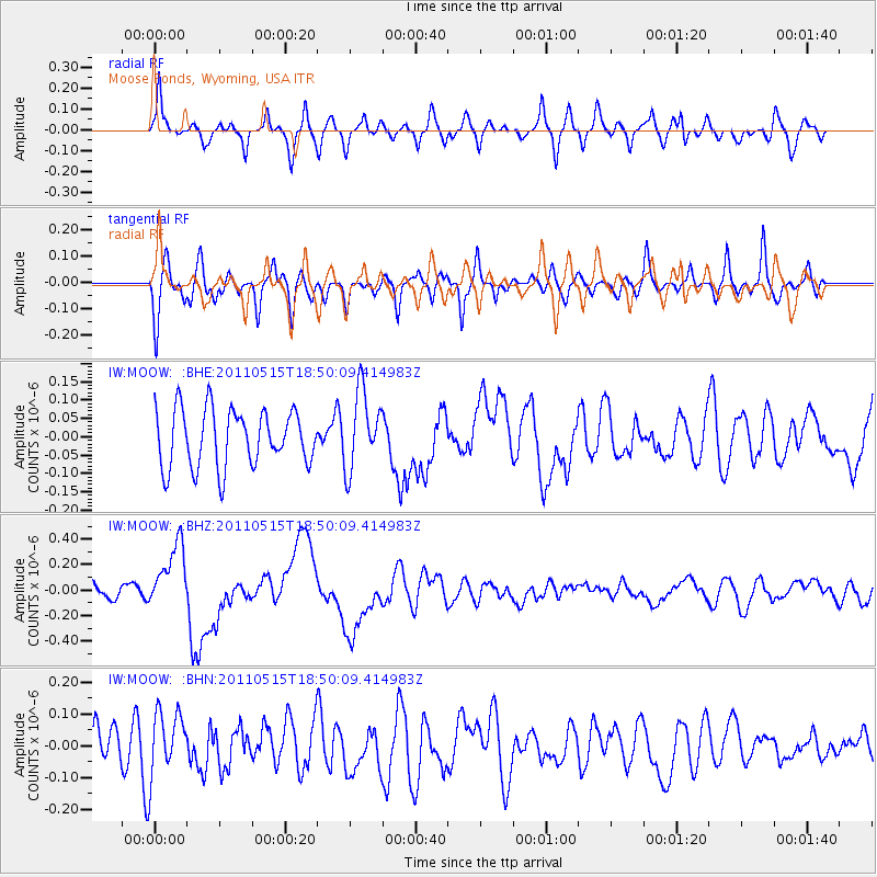
MOOW Moose Ponds, Wyoming, USA - Earthquake Result Viewer
*The percent match for this event was below the threshold and hence no stack was calculated.
| Earthquake location: |
Solomon Islands |
| Earthquake latitude/longitude: |
-6.1/154.4 |
| Earthquake time(UTC): |
2011/05/15 (135) 18:37:10 GMT |
| Earthquake Depth: |
40 km |
| Earthquake Magnitude: |
6.3 MB, 6.2 MS, 6.5 MW, 6.5 MW |
| Earthquake Catalog/Contributor: |
WHDF/NEIC |
|
| Network: |
IW Intermountain West |
| Station: |
MOOW Moose Ponds, Wyoming, USA |
| Lat/Lon: |
43.75 N/110.74 W |
| Elevation: |
2128 m |
|
| Distance: |
97.7 deg |
| Az: |
46.773 deg |
| Baz: |
268.918 deg |
| Ray Param: |
$rayparam |
*The percent match for this event was below the threshold and hence was not used in the summary stack. |
|
| Radial Match: |
69.61417 % |
| Radial Bump: |
400 |
| Transverse Match: |
60.177525 % |
| Transverse Bump: |
400 |
| SOD ConfigId: |
391883 |
| Insert Time: |
2011-10-23 00:05:39.684 +0000 |
| GWidth: |
2.5 |
| Max Bumps: |
400 |
| Tol: |
0.001 |
|
Signal To Noise
| Channel | StoN | STA | LTA |
| IW:MOOW: :BHZ:20110515T18:50:09.414983Z | 4.3342743 | 2.5954066E-7 | 5.9880996E-8 |
| IW:MOOW: :BHN:20110515T18:50:09.414983Z | 1.4955838 | 1.0121353E-7 | 6.7674925E-8 |
| IW:MOOW: :BHE:20110515T18:50:09.414983Z | 1.3753155 | 1.0680261E-7 | 7.76568E-8 |
| Arrivals |
| Ps | |
| PpPs | |
| PsPs/PpSs | |


