You are here: Home > Network List > TA - USArray Transportable Network (new EarthScope stations) Stations List
> Station G03D McMinnville, OR, USA > Earthquake Result Viewer
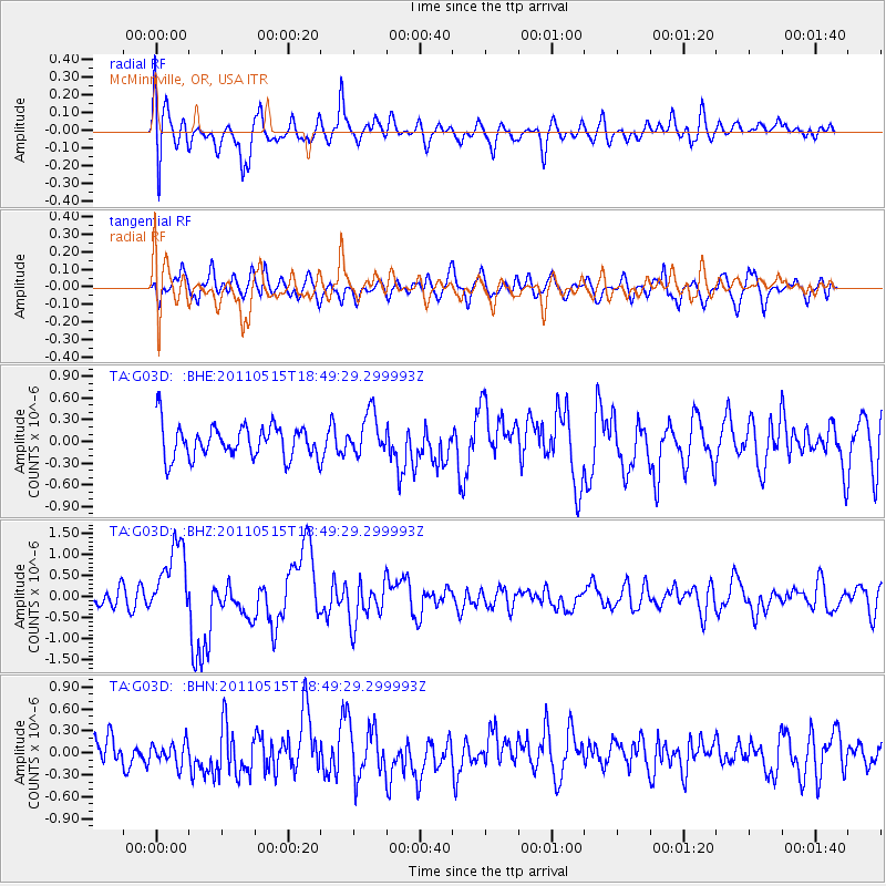
G03D McMinnville, OR, USA - Earthquake Result Viewer
*The percent match for this event was below the threshold and hence no stack was calculated.
| Earthquake location: |
Solomon Islands |
| Earthquake latitude/longitude: |
-6.1/154.4 |
| Earthquake time(UTC): |
2011/05/15 (135) 18:37:10 GMT |
| Earthquake Depth: |
40 km |
| Earthquake Magnitude: |
6.3 MB, 6.2 MS, 6.5 MW, 6.5 MW |
| Earthquake Catalog/Contributor: |
WHDF/NEIC |
|
| Network: |
TA USArray Transportable Network (new EarthScope stations) |
| Station: |
G03D McMinnville, OR, USA |
| Lat/Lon: |
45.21 N/123.26 W |
| Elevation: |
222 m |
|
| Distance: |
88.9 deg |
| Az: |
44.48 deg |
| Baz: |
260.289 deg |
| Ray Param: |
$rayparam |
*The percent match for this event was below the threshold and hence was not used in the summary stack. |
|
| Radial Match: |
74.04035 % |
| Radial Bump: |
400 |
| Transverse Match: |
61.946915 % |
| Transverse Bump: |
400 |
| SOD ConfigId: |
391883 |
| Insert Time: |
2011-10-23 00:09:00.850 +0000 |
| GWidth: |
2.5 |
| Max Bumps: |
400 |
| Tol: |
0.001 |
|
Signal To Noise
| Channel | StoN | STA | LTA |
| TA:G03D: :BHZ:20110515T18:49:29.299993Z | 4.112306 | 8.7854556E-7 | 2.1363817E-7 |
| TA:G03D: :BHN:20110515T18:49:29.299993Z | 0.623761 | 1.4600919E-7 | 2.3407873E-7 |
| TA:G03D: :BHE:20110515T18:49:29.299993Z | 1.2788426 | 2.8935077E-7 | 2.2625989E-7 |
| Arrivals |
| Ps | |
| PpPs | |
| PsPs/PpSs | |


