You are here: Home > Network List > TA - USArray Transportable Network (new EarthScope stations) Stations List
> Station I03D Drain, OR, USA > Earthquake Result Viewer
I03D Drain, OR, USA - Earthquake Result Viewer

| Earthquake location: |
Solomon Islands |
| Earthquake latitude/longitude: |
-6.1/154.4 |
| Earthquake time(UTC): |
2011/05/15 (135) 18:37:10 GMT |
| Earthquake Depth: |
40 km |
| Earthquake Magnitude: |
6.3 MB, 6.2 MS, 6.5 MW, 6.5 MW |
| Earthquake Catalog/Contributor: |
WHDF/NEIC |
|
| Network: |
TA USArray Transportable Network (new EarthScope stations) |
| Station: |
I03D Drain, OR, USA |
| Lat/Lon: |
43.70 N/123.35 W |
| Elevation: |
140 m |
|
| Distance: |
88.6 deg |
| Az: |
45.963 deg |
| Baz: |
260.263 deg |
| Ray Param: |
0.042418957 |
| Estimated Moho Depth: |
48.0 km |
| Estimated Crust Vp/Vs: |
1.60 |
| Assumed Crust Vp: |
6.522 km/s |
| Estimated Crust Vs: |
4.07 km/s |
| Estimated Crust Poisson's Ratio: |
0.18 |
|
| Radial Match: |
81.443 % |
| Radial Bump: |
400 |
| Transverse Match: |
62.63638 % |
| Transverse Bump: |
400 |
| SOD ConfigId: |
391883 |
| Insert Time: |
2011-10-23 00:09:02.810 +0000 |
| GWidth: |
2.5 |
| Max Bumps: |
400 |
| Tol: |
0.001 |
|
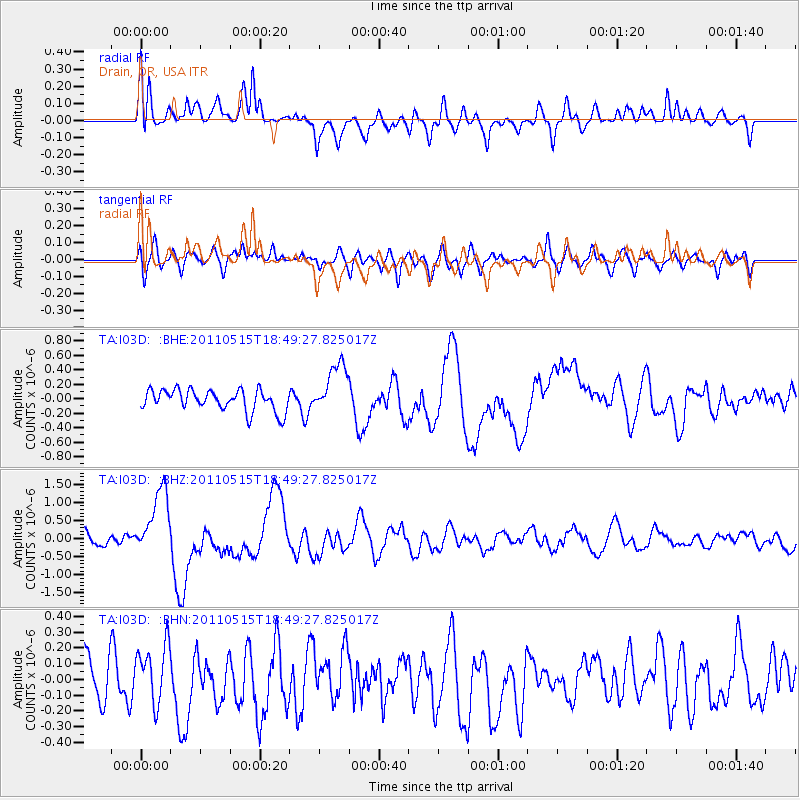
Signal To Noise
| Channel | StoN | STA | LTA |
| TA:I03D: :BHZ:20110515T18:49:27.825017Z | 5.6814 | 9.4124005E-7 | 1.6567044E-7 |
| TA:I03D: :BHN:20110515T18:49:27.825017Z | 0.8451637 | 1.7758516E-7 | 2.1011925E-7 |
| TA:I03D: :BHE:20110515T18:49:27.825017Z | 2.4166145 | 3.5351087E-7 | 1.4628351E-7 |
| Arrivals |
| Ps | 4.5 SECOND |
| PpPs | 19 SECOND |
| PsPs/PpSs | 23 SECOND |


