You are here: Home > Network List > TA - USArray Transportable Network (new EarthScope stations) Stations List
> Station Q61A Milford, DE, USA > Earthquake Result Viewer
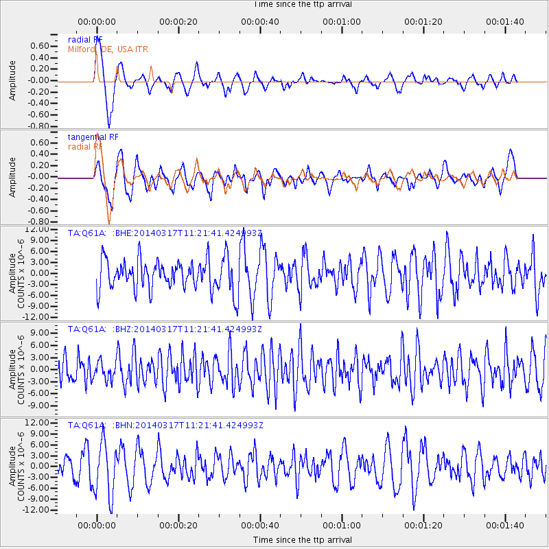
Q61A Milford, DE, USA - Earthquake Result Viewer
*The percent match for this event was below the threshold and hence no stack was calculated.
| Earthquake location: |
Near Coast Of Northern Chile |
| Earthquake latitude/longitude: |
-19.9/-70.9 |
| Earthquake time(UTC): |
2014/03/17 (076) 11:12:17 GMT |
| Earthquake Depth: |
26 km |
| Earthquake Magnitude: |
5.0 MW |
| Earthquake Catalog/Contributor: |
ISC/ISC |
|
| Network: |
TA USArray Transportable Network (new EarthScope stations) |
| Station: |
Q61A Milford, DE, USA |
| Lat/Lon: |
38.88 N/75.33 W |
| Elevation: |
5.0 m |
|
| Distance: |
58.7 deg |
| Az: |
355.912 deg |
| Baz: |
175.071 deg |
| Ray Param: |
$rayparam |
*The percent match for this event was below the threshold and hence was not used in the summary stack. |
|
| Radial Match: |
74.92559 % |
| Radial Bump: |
400 |
| Transverse Match: |
63.27987 % |
| Transverse Bump: |
400 |
| SOD ConfigId: |
3390531 |
| Insert Time: |
2019-04-10 17:38:58.419 +0000 |
| GWidth: |
2.5 |
| Max Bumps: |
400 |
| Tol: |
0.001 |
|
Signal To Noise
| Channel | StoN | STA | LTA |
| TA:Q61A: :BHZ:20140317T11:21:41.424993Z | 0.7292643 | 2.2361012E-6 | 3.0662425E-6 |
| TA:Q61A: :BHN:20140317T11:21:41.424993Z | 2.9144354 | 7.459447E-6 | 2.5594827E-6 |
| TA:Q61A: :BHE:20140317T11:21:41.424993Z | 1.6311777 | 5.859402E-6 | 3.5921298E-6 |
| Arrivals |
| Ps | |
| PpPs | |
| PsPs/PpSs | |


