You are here: Home > Network List > TA - USArray Transportable Network (new EarthScope stations) Stations List
> Station V38A Canehill, AR, USA > Earthquake Result Viewer
V38A Canehill, AR, USA - Earthquake Result Viewer
*The percent match for this event was below the threshold and hence no stack was calculated.
| Earthquake location: |
Turkey |
| Earthquake latitude/longitude: |
39.1/29.1 |
| Earthquake time(UTC): |
2011/05/19 (139) 20:15:22 GMT |
| Earthquake Depth: |
7.0 km |
| Earthquake Magnitude: |
5.8 MB, 5.8 MS, 5.9 MW, 5.8 MW |
| Earthquake Catalog/Contributor: |
WHDF/NEIC |
|
| Network: |
TA USArray Transportable Network (new EarthScope stations) |
| Station: |
V38A Canehill, AR, USA |
| Lat/Lon: |
35.86 N/94.41 W |
| Elevation: |
372 m |
|
| Distance: |
89.0 deg |
| Az: |
317.361 deg |
| Baz: |
40.424 deg |
| Ray Param: |
$rayparam |
*The percent match for this event was below the threshold and hence was not used in the summary stack. |
|
| Radial Match: |
63.809807 % |
| Radial Bump: |
400 |
| Transverse Match: |
64.97073 % |
| Transverse Bump: |
400 |
| SOD ConfigId: |
391883 |
| Insert Time: |
2011-10-23 00:51:54.607 +0000 |
| GWidth: |
2.5 |
| Max Bumps: |
400 |
| Tol: |
0.001 |
|
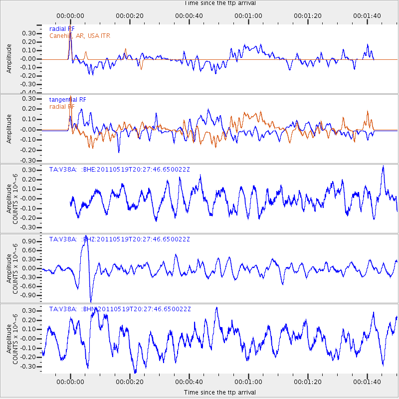
Signal To Noise
| Channel | StoN | STA | LTA |
| TA:V38A: :BHZ:20110519T20:27:46.650022Z | 4.7160606 | 4.4958693E-7 | 9.533103E-8 |
| TA:V38A: :BHN:20110519T20:27:46.650022Z | 1.090475 | 1.1377412E-7 | 1.0433446E-7 |
| TA:V38A: :BHE:20110519T20:27:46.650022Z | 1.3732536 | 1.09696906E-7 | 7.9881026E-8 |
| Arrivals |
| Ps | |
| PpPs | |
| PsPs/PpSs | |


