You are here: Home > Network List > TA - USArray Transportable Network (new EarthScope stations) Stations List
> Station P39B Salisbury, MO, USA > Earthquake Result Viewer
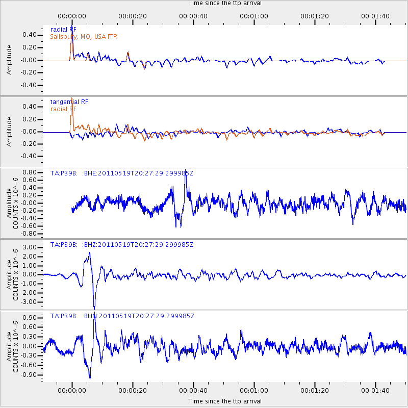
P39B Salisbury, MO, USA - Earthquake Result Viewer
*The percent match for this event was below the threshold and hence no stack was calculated.
| Earthquake location: |
Turkey |
| Earthquake latitude/longitude: |
39.1/29.1 |
| Earthquake time(UTC): |
2011/05/19 (139) 20:15:22 GMT |
| Earthquake Depth: |
7.0 km |
| Earthquake Magnitude: |
5.8 MB, 5.8 MS, 5.9 MW, 5.8 MW |
| Earthquake Catalog/Contributor: |
WHDF/NEIC |
|
| Network: |
TA USArray Transportable Network (new EarthScope stations) |
| Station: |
P39B Salisbury, MO, USA |
| Lat/Lon: |
39.49 N/92.75 W |
| Elevation: |
226 m |
|
| Distance: |
85.4 deg |
| Az: |
318.743 deg |
| Baz: |
41.499 deg |
| Ray Param: |
$rayparam |
*The percent match for this event was below the threshold and hence was not used in the summary stack. |
|
| Radial Match: |
75.26211 % |
| Radial Bump: |
400 |
| Transverse Match: |
64.0954 % |
| Transverse Bump: |
400 |
| SOD ConfigId: |
391883 |
| Insert Time: |
2011-10-23 01:05:55.681 +0000 |
| GWidth: |
2.5 |
| Max Bumps: |
400 |
| Tol: |
0.001 |
|
Signal To Noise
| Channel | StoN | STA | LTA |
| TA:P39B: :BHZ:20110519T20:27:29.299985Z | 7.823661 | 8.5628534E-7 | 1.09448166E-7 |
| TA:P39B: :BHN:20110519T20:27:29.299985Z | 1.831409 | 2.8157805E-7 | 1.5374943E-7 |
| TA:P39B: :BHE:20110519T20:27:29.299985Z | 2.0974004 | 2.348762E-7 | 1.11984434E-7 |
| Arrivals |
| Ps | |
| PpPs | |
| PsPs/PpSs | |


