You are here: Home > Network List > TA - USArray Transportable Network (new EarthScope stations) Stations List
> Station O03D Paynes Creek, CA, USA > Earthquake Result Viewer
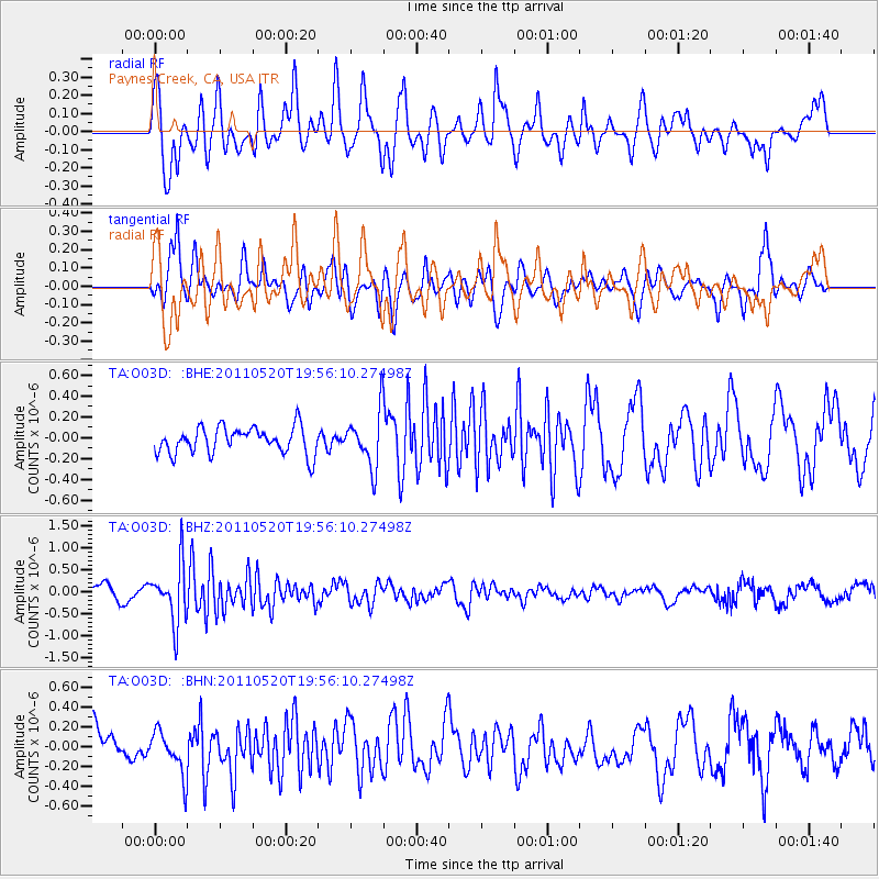
O03D Paynes Creek, CA, USA - Earthquake Result Viewer
*The percent match for this event was below the threshold and hence no stack was calculated.
| Earthquake location: |
Eastern New Guinea Reg., P.N.G. |
| Earthquake latitude/longitude: |
-7.2/146.9 |
| Earthquake time(UTC): |
2011/05/20 (140) 19:43:16 GMT |
| Earthquake Depth: |
7.0 km |
| Earthquake Magnitude: |
6.2 MB, 5.5 MS, 5.7 MW, 5.7 MW |
| Earthquake Catalog/Contributor: |
WHDF/NEIC |
|
| Network: |
TA USArray Transportable Network (new EarthScope stations) |
| Station: |
O03D Paynes Creek, CA, USA |
| Lat/Lon: |
40.29 N/121.80 W |
| Elevation: |
968 m |
|
| Distance: |
95.6 deg |
| Az: |
50.202 deg |
| Baz: |
265.347 deg |
| Ray Param: |
$rayparam |
*The percent match for this event was below the threshold and hence was not used in the summary stack. |
|
| Radial Match: |
75.85248 % |
| Radial Bump: |
400 |
| Transverse Match: |
68.39475 % |
| Transverse Bump: |
400 |
| SOD ConfigId: |
391883 |
| Insert Time: |
2011-10-23 01:19:44.235 +0000 |
| GWidth: |
2.5 |
| Max Bumps: |
400 |
| Tol: |
0.001 |
|
Signal To Noise
| Channel | StoN | STA | LTA |
| TA:O03D: :BHZ:20110520T19:56:10.27498Z | 3.8574314 | 6.566275E-7 | 1.7022403E-7 |
| TA:O03D: :BHN:20110520T19:56:10.27498Z | 1.2078462 | 2.1935242E-7 | 1.8160624E-7 |
| TA:O03D: :BHE:20110520T19:56:10.27498Z | 2.0721548 | 2.6595308E-7 | 1.2834614E-7 |
| Arrivals |
| Ps | |
| PpPs | |
| PsPs/PpSs | |


