You are here: Home > Network List > UW - Pacific Northwest Regional Seismic Network Stations List
> Station LEBA Lebam, WA, USA > Earthquake Result Viewer
LEBA Lebam, WA, USA - Earthquake Result Viewer
*The percent match for this event was below the threshold and hence no stack was calculated.
| Earthquake location: |
Eastern New Guinea Reg., P.N.G. |
| Earthquake latitude/longitude: |
-7.2/146.9 |
| Earthquake time(UTC): |
2011/05/20 (140) 19:43:16 GMT |
| Earthquake Depth: |
7.0 km |
| Earthquake Magnitude: |
6.2 MB, 5.5 MS, 5.7 MW, 5.7 MW |
| Earthquake Catalog/Contributor: |
WHDF/NEIC |
|
| Network: |
UW Pacific Northwest Regional Seismic Network |
| Station: |
LEBA Lebam, WA, USA |
| Lat/Lon: |
46.55 N/123.56 W |
| Elevation: |
73 m |
|
| Distance: |
94.8 deg |
| Az: |
43.84 deg |
| Baz: |
264.716 deg |
| Ray Param: |
$rayparam |
*The percent match for this event was below the threshold and hence was not used in the summary stack. |
|
| Radial Match: |
52.783695 % |
| Radial Bump: |
400 |
| Transverse Match: |
61.977005 % |
| Transverse Bump: |
400 |
| SOD ConfigId: |
391883 |
| Insert Time: |
2011-10-23 01:21:50.932 +0000 |
| GWidth: |
2.5 |
| Max Bumps: |
400 |
| Tol: |
0.001 |
|
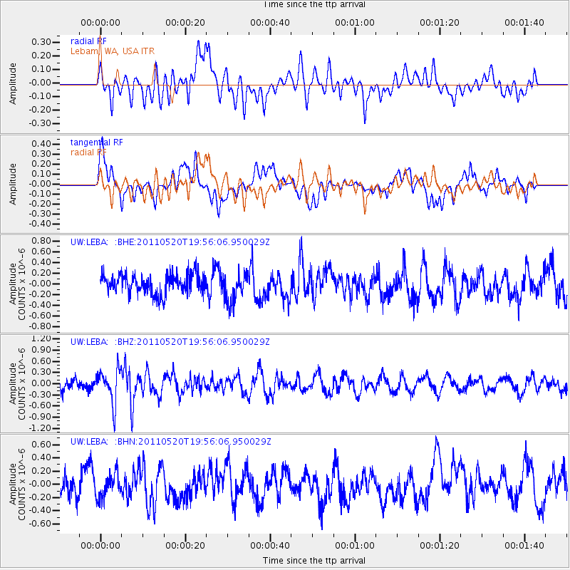
Signal To Noise
| Channel | StoN | STA | LTA |
| UW:LEBA: :BHZ:20110520T19:56:06.950029Z | 2.4492598 | 4.6654742E-7 | 1.9048507E-7 |
| UW:LEBA: :BHN:20110520T19:56:06.950029Z | 0.9875236 | 1.846863E-7 | 1.8701964E-7 |
| UW:LEBA: :BHE:20110520T19:56:06.950029Z | 1.5660027 | 2.8302983E-7 | 1.8073393E-7 |
| Arrivals |
| Ps | |
| PpPs | |
| PsPs/PpSs | |


