You are here: Home > Network List > CN - Canadian National Seismograph Network Stations List
> Station INK INUVIK, NT, CANADA.ANADA > Earthquake Result Viewer
INK INUVIK, NT, CANADA.ANADA - Earthquake Result Viewer
| Earthquake location: |
Hindu Kush Region, Afghanistan |
| Earthquake latitude/longitude: |
36.4/70.7 |
| Earthquake time(UTC): |
2011/05/14 (134) 21:07:22 GMT |
| Earthquake Depth: |
207 km |
| Earthquake Magnitude: |
5.8 MB, 6.0 MW, 6.0 MW |
| Earthquake Catalog/Contributor: |
WHDF/NEIC |
|
| Network: |
CN Canadian National Seismograph Network |
| Station: |
INK INUVIK, NT, CANADA.ANADA |
| Lat/Lon: |
68.31 N/133.52 W |
| Elevation: |
40 m |
|
| Distance: |
74.0 deg |
| Az: |
9.146 deg |
| Baz: |
339.826 deg |
| Ray Param: |
0.052051265 |
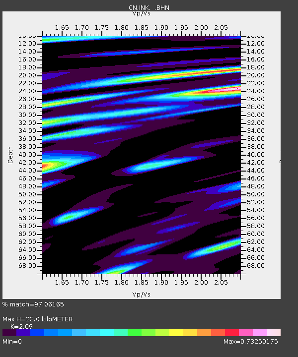
| Estimated Moho Depth: |
23.0 km |
| Estimated Crust Vp/Vs: |
2.09 |
| Assumed Crust Vp: |
6.171 km/s |
| Estimated Crust Vs: |
2.953 km/s |
| Estimated Crust Poisson's Ratio: |
0.35 |
|
| Radial Match: |
97.06165 % |
| Radial Bump: |
355 |
| Transverse Match: |
83.328384 % |
| Transverse Bump: |
400 |
| SOD ConfigId: |
393008 |
| Insert Time: |
2011-10-25 17:42:26.942 +0000 |
| GWidth: |
2.5 |
| Max Bumps: |
400 |
| Tol: |
0.001 |
|
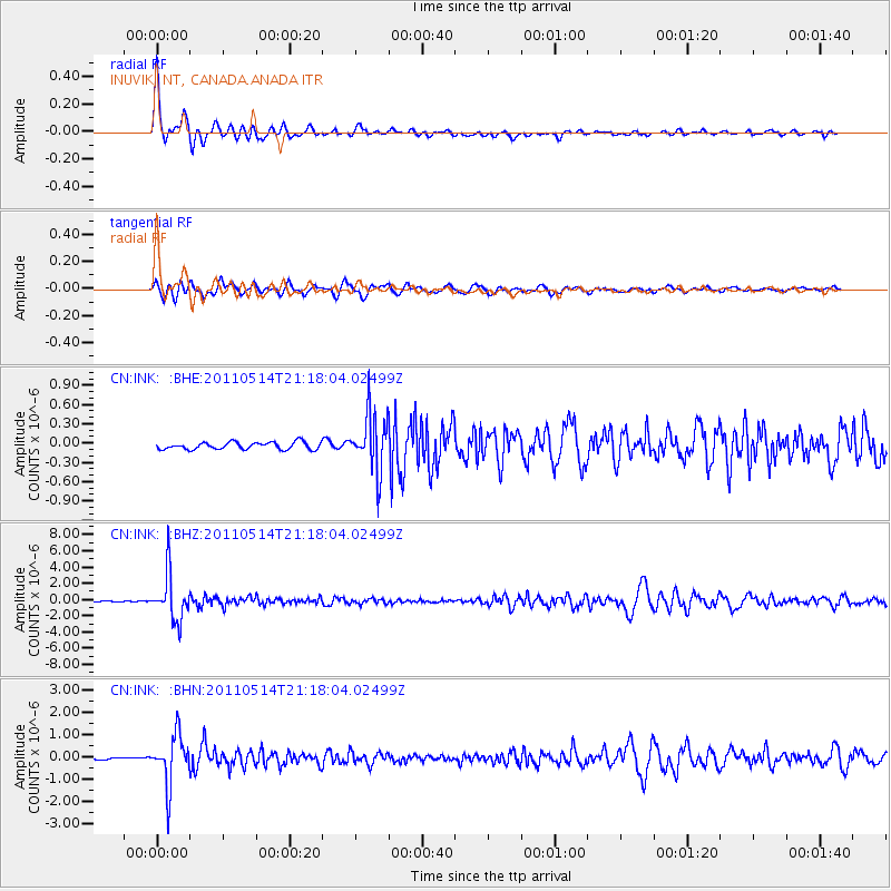
Signal To Noise
| Channel | StoN | STA | LTA |
| CN:INK: :BHZ:20110514T21:18:04.02499Z | 55.534863 | 2.880839E-6 | 5.1874423E-8 |
| CN:INK: :BHN:20110514T21:18:04.02499Z | 17.074068 | 1.1404102E-6 | 6.679195E-8 |
| CN:INK: :BHE:20110514T21:18:04.02499Z | 8.078704 | 4.4385789E-7 | 5.494172E-8 |
| Arrivals |
| Ps | 4.2 SECOND |
| PpPs | 11 SECOND |
| PsPs/PpSs | 15 SECOND |


