You are here: Home > Network List > CN - Canadian National Seismograph Network Stations List
> Station YKW3 > Earthquake Result Viewer
YKW3 - Earthquake Result Viewer
| Earthquake location: |
Hindu Kush Region, Afghanistan |
| Earthquake latitude/longitude: |
36.4/70.7 |
| Earthquake time(UTC): |
2011/05/14 (134) 21:07:22 GMT |
| Earthquake Depth: |
207 km |
| Earthquake Magnitude: |
5.8 MB, 6.0 MW, 6.0 MW |
| Earthquake Catalog/Contributor: |
WHDF/NEIC |
|
| Network: |
CN Canadian National Seismograph Network |
| Station: |
YKW3 |
| Lat/Lon: |
62.56 N/114.62 W |
| Elevation: |
200 m |
|
| Distance: |
81.3 deg |
| Az: |
2.511 deg |
| Baz: |
355.624 deg |
| Ray Param: |
0.04718072 |
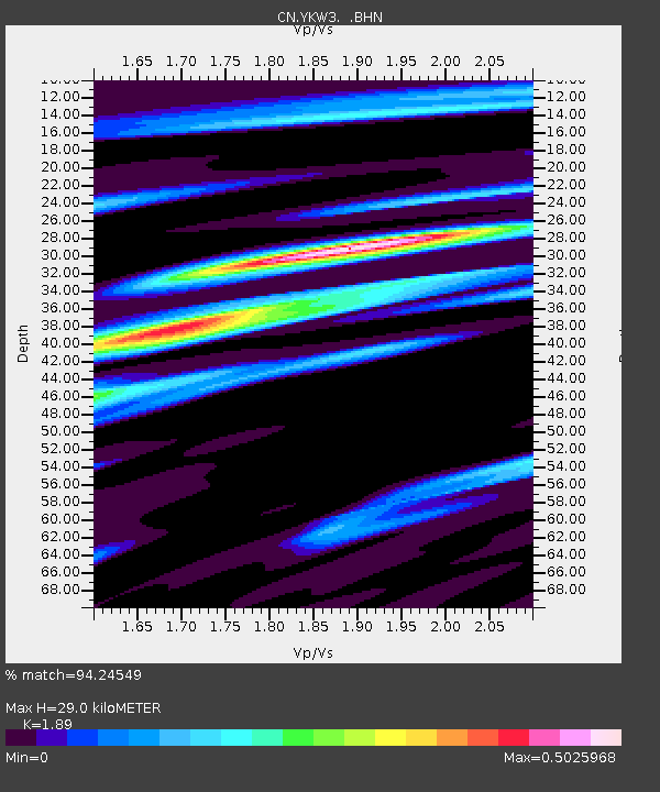
| Estimated Moho Depth: |
29.0 km |
| Estimated Crust Vp/Vs: |
1.89 |
| Assumed Crust Vp: |
6.459 km/s |
| Estimated Crust Vs: |
3.418 km/s |
| Estimated Crust Poisson's Ratio: |
0.31 |
|
| Radial Match: |
94.24549 % |
| Radial Bump: |
277 |
| Transverse Match: |
94.2455 % |
| Transverse Bump: |
277 |
| SOD ConfigId: |
393008 |
| Insert Time: |
2011-10-25 17:42:44.995 +0000 |
| GWidth: |
2.5 |
| Max Bumps: |
400 |
| Tol: |
0.001 |
|

Signal To Noise
| Channel | StoN | STA | LTA |
| CN:YKW3: :BHZ:20110514T21:18:43.949978Z | 38.682774 | 3.347028E-8 | 8.652502E-10 |
| CN:YKW3: :BHN:20110514T21:18:43.949978Z | 12.484078 | 1.1084984E-8 | 8.8792973E-10 |
| $trig.getChannelId() | $trig.getValue() | $trig.getSTA() | $trig.getLTA() |
| Arrivals |
| Ps | 4.1 SECOND |
| PpPs | 13 SECOND |
| PsPs/PpSs | 17 SECOND |


