You are here: Home > Network List > G - GEOSCOPE Stations List
> Station INU Inuyama, Japan > Earthquake Result Viewer
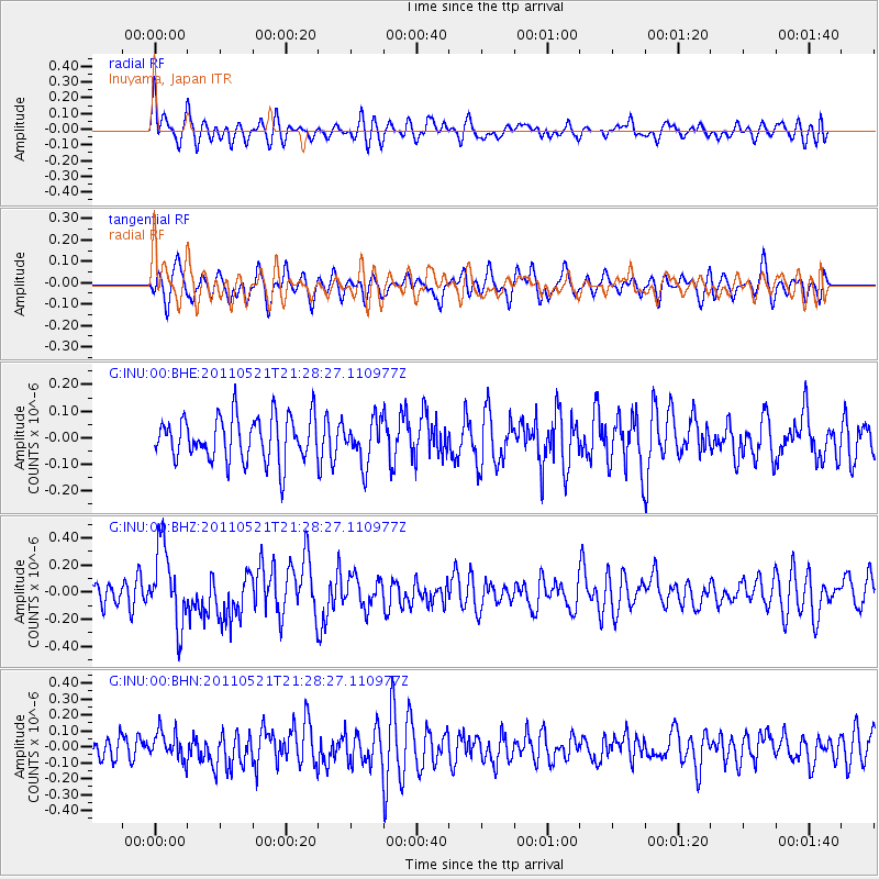
INU Inuyama, Japan - Earthquake Result Viewer
*The percent match for this event was below the threshold and hence no stack was calculated.
| Earthquake location: |
Kermadec Islands, New Zealand |
| Earthquake latitude/longitude: |
-30.8/-178.2 |
| Earthquake time(UTC): |
2011/05/21 (141) 21:17:02 GMT |
| Earthquake Depth: |
34 km |
| Earthquake Magnitude: |
5.5 MB, 5.4 MS, 5.8 MW, 5.8 MW |
| Earthquake Catalog/Contributor: |
WHDF/NEIC |
|
| Network: |
G GEOSCOPE |
| Station: |
INU Inuyama, Japan |
| Lat/Lon: |
35.35 N/137.03 E |
| Elevation: |
132 m |
|
| Distance: |
78.2 deg |
| Az: |
323.945 deg |
| Baz: |
141.729 deg |
| Ray Param: |
$rayparam |
*The percent match for this event was below the threshold and hence was not used in the summary stack. |
|
| Radial Match: |
51.638985 % |
| Radial Bump: |
400 |
| Transverse Match: |
52.338127 % |
| Transverse Bump: |
400 |
| SOD ConfigId: |
393008 |
| Insert Time: |
2011-10-28 07:49:23.956 +0000 |
| GWidth: |
2.5 |
| Max Bumps: |
400 |
| Tol: |
0.001 |
|
Signal To Noise
| Channel | StoN | STA | LTA |
| G:INU:00:BHZ:20110521T21:28:27.110977Z | 3.590014 | 2.8308068E-7 | 7.8852246E-8 |
| G:INU:00:BHN:20110521T21:28:27.110977Z | 0.88603556 | 8.867613E-8 | 1.0008191E-7 |
| G:INU:00:BHE:20110521T21:28:27.110977Z | 0.9708718 | 8.098942E-8 | 8.341927E-8 |
| Arrivals |
| Ps | |
| PpPs | |
| PsPs/PpSs | |


