You are here: Home > Network List > TA - USArray Transportable Network (new EarthScope stations) Stations List
> Station R11A Troy Canyon, Currant, NV, USA > Earthquake Result Viewer
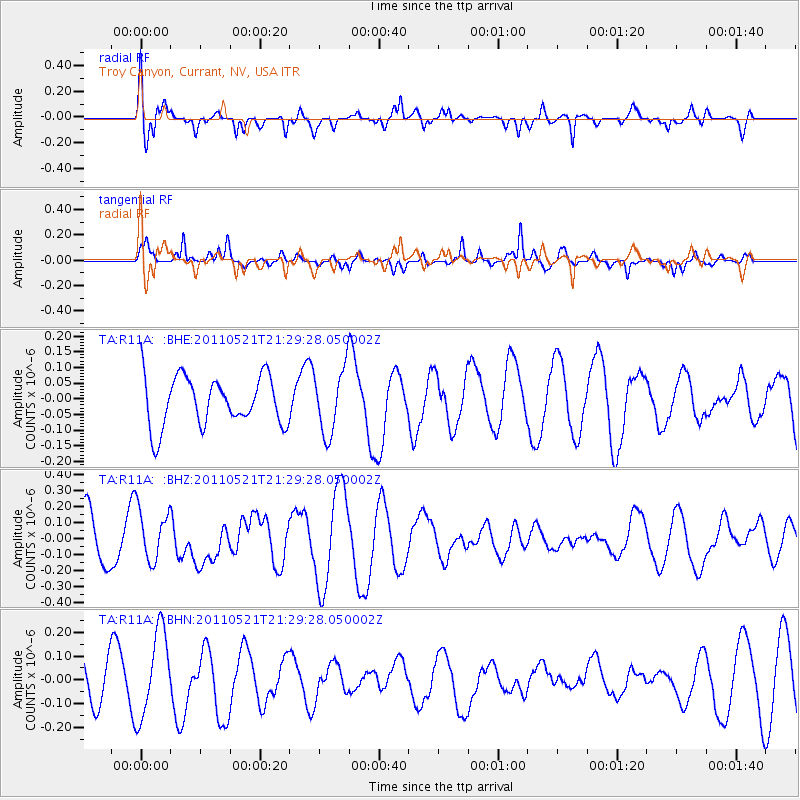
R11A Troy Canyon, Currant, NV, USA - Earthquake Result Viewer
*The percent match for this event was below the threshold and hence no stack was calculated.
| Earthquake location: |
Kermadec Islands, New Zealand |
| Earthquake latitude/longitude: |
-30.8/-178.2 |
| Earthquake time(UTC): |
2011/05/21 (141) 21:17:02 GMT |
| Earthquake Depth: |
34 km |
| Earthquake Magnitude: |
5.5 MB, 5.4 MS, 5.8 MW, 5.8 MW |
| Earthquake Catalog/Contributor: |
WHDF/NEIC |
|
| Network: |
TA USArray Transportable Network (new EarthScope stations) |
| Station: |
R11A Troy Canyon, Currant, NV, USA |
| Lat/Lon: |
38.35 N/115.59 W |
| Elevation: |
1756 m |
|
| Distance: |
90.2 deg |
| Az: |
44.264 deg |
| Baz: |
229.788 deg |
| Ray Param: |
$rayparam |
*The percent match for this event was below the threshold and hence was not used in the summary stack. |
|
| Radial Match: |
77.395195 % |
| Radial Bump: |
400 |
| Transverse Match: |
62.086327 % |
| Transverse Bump: |
314 |
| SOD ConfigId: |
393008 |
| Insert Time: |
2011-10-28 07:52:30.113 +0000 |
| GWidth: |
2.5 |
| Max Bumps: |
400 |
| Tol: |
0.001 |
|
Signal To Noise
| Channel | StoN | STA | LTA |
| TA:R11A: :BHZ:20110521T21:29:28.050002Z | 1.4401077 | 1.6199441E-7 | 1.124877E-7 |
| TA:R11A: :BHN:20110521T21:29:28.050002Z | 2.5821533 | 1.8213966E-7 | 7.0537894E-8 |
| TA:R11A: :BHE:20110521T21:29:28.050002Z | 1.3169832 | 1.0332454E-7 | 7.845547E-8 |
| Arrivals |
| Ps | |
| PpPs | |
| PsPs/PpSs | |


