You are here: Home > Network List > TA - USArray Transportable Network (new EarthScope stations) Stations List
> Station 535A Dale, TX, USA > Earthquake Result Viewer
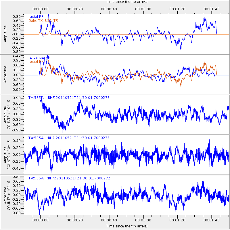
535A Dale, TX, USA - Earthquake Result Viewer
*The percent match for this event was below the threshold and hence no stack was calculated.
| Earthquake location: |
Kermadec Islands, New Zealand |
| Earthquake latitude/longitude: |
-30.8/-178.2 |
| Earthquake time(UTC): |
2011/05/21 (141) 21:17:02 GMT |
| Earthquake Depth: |
34 km |
| Earthquake Magnitude: |
5.5 MB, 5.4 MS, 5.8 MW, 5.8 MW |
| Earthquake Catalog/Contributor: |
WHDF/NEIC |
|
| Network: |
TA USArray Transportable Network (new EarthScope stations) |
| Station: |
535A Dale, TX, USA |
| Lat/Lon: |
30.03 N/97.57 W |
| Elevation: |
170 m |
|
| Distance: |
97.6 deg |
| Az: |
59.67 deg |
| Baz: |
238.894 deg |
| Ray Param: |
$rayparam |
*The percent match for this event was below the threshold and hence was not used in the summary stack. |
|
| Radial Match: |
53.633553 % |
| Radial Bump: |
400 |
| Transverse Match: |
52.165962 % |
| Transverse Bump: |
400 |
| SOD ConfigId: |
393008 |
| Insert Time: |
2011-10-28 07:53:17.409 +0000 |
| GWidth: |
2.5 |
| Max Bumps: |
400 |
| Tol: |
0.001 |
|
Signal To Noise
| Channel | StoN | STA | LTA |
| TA:535A: :BHZ:20110521T21:30:01.700027Z | 1.1561666 | 1.599754E-7 | 1.3836708E-7 |
| TA:535A: :BHN:20110521T21:30:01.700027Z | 2.5384865 | 4.80862E-7 | 1.8942863E-7 |
| TA:535A: :BHE:20110521T21:30:01.700027Z | 0.6561253 | 2.9211859E-7 | 4.4521767E-7 |
| Arrivals |
| Ps | |
| PpPs | |
| PsPs/PpSs | |


